Yutz elevation
Yutz (Grand Est, Moselle), France elevation is 156 meters and Yutz elevation in feet is 512 ft above sea level [src 1]. Yutz is a populated place (feature code) with elevation that is 18 meters (59 ft) smaller than average city elevation in France.
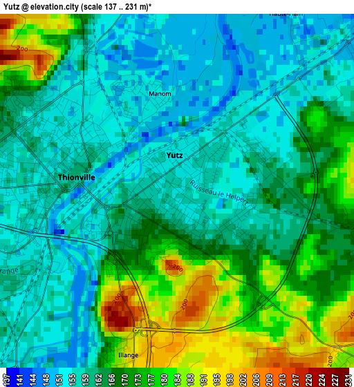
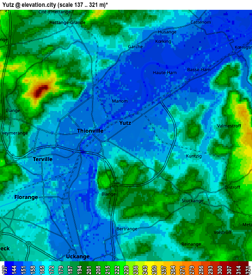
Below is the Elevation map of Yutz, which displays elevation range with different colors. Scale of the first map is from 137 to 231 m (449 to 758 ft) with average elevation of 165.6 meters (=543 ft) [note 1]
These maps also provides idea of topography and contour of this city, they are displayed at different zoom levels. More info about maps, scale and edge coordinates you can find below images.
| \ | Map #1 | Map #2 | Topo.Map |
| Scale [m] | 137..231 m | 137..321 m | × |
| Scale [ft] | 449..758 ft | 449..1053 ft | × |
| Average | 165.6 m = 543 ft | 176.5 m = 579 ft | × |
| Width | 6.37 km = 4 mi | 12.73 km = 7.9 mi | 203.7 km = 126.6 mi |
| Height | 6.37 km = 4 mi | 12.73 km = 7.9 mi | 203.7 km = 126.6 mi |
| ↑Max Latitude | 49.384326° | 49.412925° | 50.26317° |
| Latitude at center | 49.35571° | 49.35571° | 49.35571° |
| ↓Min Latitude | 49.327077° | 49.298428° | 48.43119° |
| ← Min Longitude | 6.148655° | 6.104709° | 4.78635° |
| Longitude center | 6.1926° | 6.1926° | 6.1926° |
| →Max Longitude | 6.236545° | 6.280491° | 7.59885° |
Nearby cities:
Cities around Yutz sort by population:
• Thionville elevation 151 m
2.4 km,  281°
281°
• Florange 171 m
6.3 km,  235°
235°
• Guénange 192 m
6.3 km,  171°
171°
• Uckange 157 m
6.6 km,  208°
208°
• Hettange-Grande 180 m
6.4 km,  332°
332°
• Terville 157 m
4.4 km,  256°
256°
• Manom 150 m
1.8 km,  338°
338°
• Illange 201 m
3.4 km,  196°
196°
• Bertrange 163 m
4.7 km,  180°
180°
• Basse-Ham 151 m
4.9 km,  46°
46°
• Distroff 210 m
5.9 km,  115°
115°
• Kuntzig 170 m
3.4 km,  106°
106°
Multilingual:
 En español:
Yutz elevación 156 m.
 En France:
Yutz élévation 156 m.


Sources and notes:
- [note 1] Map square and city borders are not equal. Map elevation data is calculated only from area inside that square.
- [src 1] Elevation data from geonames database provided with same terms of usage.
- [src 2] The elevation map of Yutz is generated using elevation data from NASA's 3 arcsec (90m) resolution SRTM data.
- [src 3] Base (background) map © OpenStreetMap contributors tiles are generated by Geofabrik and OpenTopoMap.
Copyright & License:
This Yutz Elevation Map is licensed under CC BY-SA. You may reuse any part from this page, if you give a proper credit by linking to this URL:
 More info on terms of use page.