Henrichemont elevation
Henrichemont (Centre, Cher), France elevation is 286 meters and Henrichemont elevation in feet is 938 ft above sea level [src 1]. Henrichemont is a populated place (feature code) with elevation that is 112 meters (367 ft) bigger than average city elevation in France.
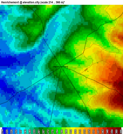
Below is the Elevation map of Henrichemont, which displays elevation range with different colors. Scale of the first map is from 214 to 366 m (702 to 1201 ft) with average elevation of 266.6 meters (=875 ft) [note 1]
These maps also provides idea of topography and contour of this city, they are displayed at different zoom levels. More info about maps, scale and edge coordinates you can find below images.
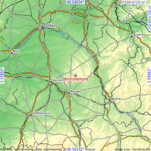
| \ | Map #1 | Topo.Map |
| Scale [m] | 214..366 m | × |
| Scale [ft] | 702..1201 ft | × |
| Average | 266.6 m = 875 ft | × |
| Width | 6.63 km = 4.1 mi | 212.1 km = 131.8 mi |
| Height | 6.63 km = 4.1 mi | 212 km = 131.7 mi |
| ↑Max Latitude | 47.333122° | 48.24834° |
| Latitude at center | 47.30333° | 47.30333° |
| ↓Min Latitude | 47.273522° | 46.34112° |
| ← Min Longitude | 2.480635° | 1.11833° |
| Longitude center | 2.52458° | 2.52458° |
| →Max Longitude | 2.568525° | 3.93083° |
Nearby cities:
Cities around Henrichemont sort by population:
• Aubigny-sur-Nère elevation 186 m
21.5 km,  342°
342°
• Saint-Germain-du-Puy 151 m
22.8 km,  187°
187°
• Saint-Martin-d’Auxigny 161 m
13.8 km,  216°
216°
• Fussy 155 m
19.1 km,  202°
202°
• Les Aix-d’Angillon 187 m
12.3 km,  165°
165°
• Sancerre 252 m
23.5 km,  83°
83°
• Menetou-Salon 233 m
8.4 km, 199°
• Saint-Éloy-de-Gy 157 m
21.4 km, 219°
• Sainte-Solange 154 m
18.7 km, 174°
• Neuvy-sur-Barangeon 144 m
20.5 km,  273°
273°
• Vasselay 171 m
19.2 km,  212°
212°
• Rians 180 m
15.4 km,  154°
154°
Multilingual:
 En español:
Henrichemont elevación 286 m.
 En France:
Henrichemont élévation 286 m.
 Auf Deutsch:
Henrichemont höhe über dem Meeresspiegel ist 286 m.

Sources and notes:
- [note 1] Map square and city borders are not equal. Map elevation data is calculated only from area inside that square.
- [src 1] Elevation data from geonames database provided with same terms of usage.
- [src 2] The elevation map of Henrichemont is generated using elevation data from NASA's 3 arcsec (90m) resolution SRTM data.
- [src 3] Base (background) map © OpenStreetMap contributors tiles are generated by Geofabrik and OpenTopoMap.
Copyright & License:
This Henrichemont Elevation Map is licensed under CC BY-SA. You may reuse any part from this page, if you give a proper credit by linking to this URL:
 More info on terms of use page.