Herry elevation
Herry (Centre, Cher), France elevation is 161 meters and Herry elevation in feet is 528 ft above sea level [src 1]. Herry is a populated place (feature code) with elevation that is 13 meters (43 ft) smaller than average city elevation in France.
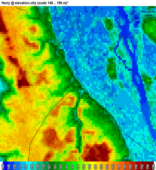
Below is the Elevation map of Herry, which displays elevation range with different colors. Scale of the first map is from 146 to 196 m (479 to 643 ft) with average elevation of 165.1 meters (=542 ft) [note 1]
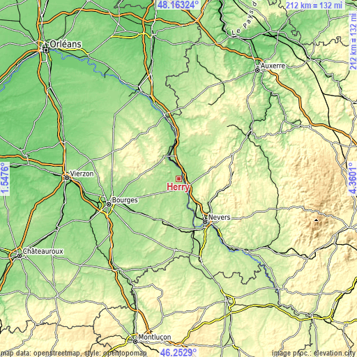
These maps also provides idea of topography and contour of this city, they are displayed at different zoom levels. More info about maps, scale and edge coordinates you can find below images.
| \ | Map #1 | Topo.Map |
| Scale [m] | 146..196 m | × |
| Scale [ft] | 479..643 ft | × |
| Average | 165.1 m = 542 ft | × |
| Width | 6.64 km = 4.1 mi | 212.4 km = 132 mi |
| Height | 6.64 km = 4.1 mi | 212.4 km = 132 mi |
| ↑Max Latitude | 47.24651° | 48.16324° |
| Latitude at center | 47.21667° | 47.21667° |
| ↓Min Latitude | 47.186813° | 46.2529° |
| ← Min Longitude | 2.909905° | 1.5476° |
| Longitude center | 2.95385° | 2.95385° |
| →Max Longitude | 2.997795° | 4.3601° |
Nearby cities:
Cities around Herry sort by population:
• Cosne-Cours-sur-Loire elevation 149 m
21.7 km,  354°
354°
• La Charité-sur-Loire 187 m
6 km,  127°
127°
• Garchizy 215 m
21.6 km,  150°
150°
• Pougues-les-Eaux 201 m
19.3 km,  144°
144°
• Sancerre 252 m
15.4 km,  324°
324°
• Saint-Satur 165 m
16.2 km,  327°
327°
• Pouilly-sur-Loire 166 m
7.5 km,  0°
0°
• Donzy 180 m
21.5 km,  37°
37°
• Jouet-sur-l'Aubois 172 m
19.2 km,  172°
172°
• Chaulgnes 226 m
14.9 km, 130°
• Baugy 170 m
22.7 km,  228°
228°
• Cours-les-Barres 178 m
22.1 km,  164°
164°
Multilingual:
 En español:
Herry elevación 161 m.
 En France:
Herry élévation 161 m.


Sources and notes:
- [note 1] Map square and city borders are not equal. Map elevation data is calculated only from area inside that square.
- [src 1] Elevation data from geonames database provided with same terms of usage.
- [src 2] The elevation map of Herry is generated using elevation data from NASA's 3 arcsec (90m) resolution SRTM data.
- [src 3] Base (background) map © OpenStreetMap contributors tiles are generated by Geofabrik and OpenTopoMap.
Copyright & License:
This Herry Elevation Map is licensed under CC BY-SA. You may reuse any part from this page, if you give a proper credit by linking to this URL:
 More info on terms of use page.