Hurigny elevation
Hurigny (Bourgogne-Franche-Comté, Département de Saône-et-Loire), France elevation is 305 meters and Hurigny elevation in feet is 1001 ft above sea level [src 1]. Hurigny is a populated place (feature code) with elevation that is 131 meters (430 ft) bigger than average city elevation in France.
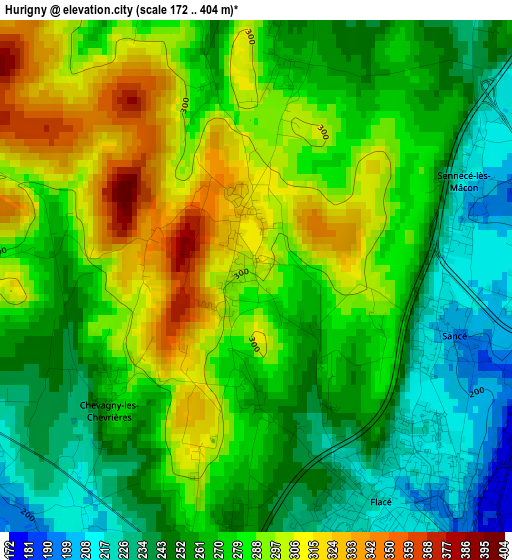
Below is the Elevation map of Hurigny, which displays elevation range with different colors. Scale of the first map is from 172 to 404 m (564 to 1325 ft) with average elevation of 272.9 meters (=895 ft) [note 1]
These maps also provides idea of topography and contour of this city, they are displayed at different zoom levels. More info about maps, scale and edge coordinates you can find below images.
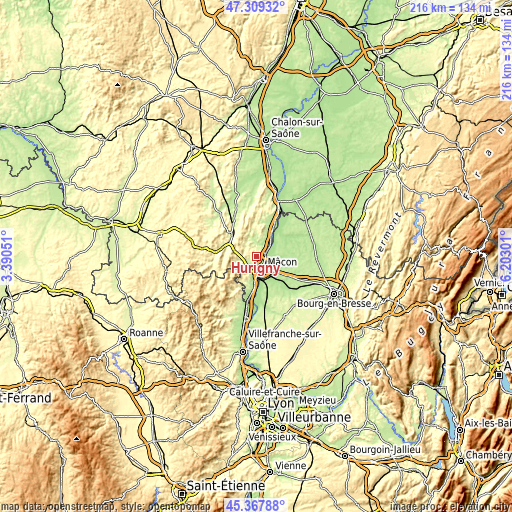
| \ | Map #1 | Topo.Map |
| Scale [m] | 172..404 m | × |
| Scale [ft] | 564..1325 ft | × |
| Average | 272.9 m = 895 ft | × |
| Width | 6.75 km = 4.2 mi | 215.9 km = 134.2 mi |
| Height | 6.75 km = 4.2 mi | 215.9 km = 134.2 mi |
| ↑Max Latitude | 46.377546° | 47.30932° |
| Latitude at center | 46.34722° | 46.34722° |
| ↓Min Latitude | 46.316877° | 45.36788° |
| ← Min Longitude | 4.752815° | 3.39051° |
| Longitude center | 4.79676° | 4.79676° |
| →Max Longitude | 4.840705° | 6.20301° |
Nearby cities:
Cities around Hurigny sort by population:
• Mâcon elevation 174 m
4.4 km,  146°
146°
• Charnay-lès-Mâcon 257 m
4.5 km,  191°
191°
• Replonges 187 m
8.4 km,  127°
127°
• Feillens 186 m
7.4 km,  101°
101°
• Sancé 194 m
2.7 km,  108°
108°
• Saint-Laurent-sur-Saône 178 m
5.8 km,  143°
143°
• Grièges 182 m
10.9 km,  158°
158°
• Manziat 201 m
8.5 km,  79°
79°
• Prissé 207 m
4.9 km,  234°
234°
• Crottet 206 m
10.9 km, 136°
• La Roche-Vineuse 230 m
5.9 km,  267°
267°
• Saint-Martin-Belle-Roche 213 m
6 km,  48°
48°
Multilingual:
 En español:
Hurigny elevación 305 m.
 En France:
Hurigny élévation 305 m.


Sources and notes:
- [note 1] Map square and city borders are not equal. Map elevation data is calculated only from area inside that square.
- [src 1] Elevation data from geonames database provided with same terms of usage.
- [src 2] The elevation map of Hurigny is generated using elevation data from NASA's 3 arcsec (90m) resolution SRTM data.
- [src 3] Base (background) map © OpenStreetMap contributors tiles are generated by Geofabrik and OpenTopoMap.
Copyright & License:
This Hurigny Elevation Map is licensed under CC BY-SA. You may reuse any part from this page, if you give a proper credit by linking to this URL:
 More info on terms of use page.