Iffendic elevation
Iffendic (Brittany, Département d'Ille-et-Vilaine), France elevation is 56 meters and Iffendic elevation in feet is 184 ft above sea level [src 1]. Iffendic is a populated place (feature code) with elevation that is 118 meters (387 ft) smaller than average city elevation in France.
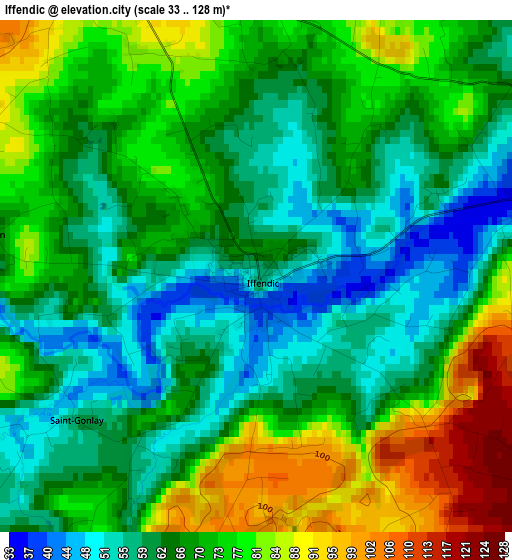
Below is the Elevation map of Iffendic, which displays elevation range with different colors. Scale of the first map is from 33 to 128 m (108 to 420 ft) with average elevation of 68.7 meters (=225 ft) [note 1]
These maps also provides idea of topography and contour of this city, they are displayed at different zoom levels. More info about maps, scale and edge coordinates you can find below images.
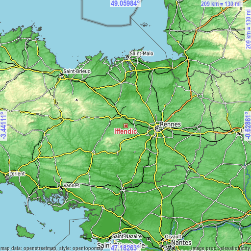
| \ | Map #1 | Topo.Map |
| Scale [m] | 33..128 m | × |
| Scale [ft] | 108..420 ft | × |
| Average | 68.7 m = 225 ft | × |
| Width | 6.52 km = 4.1 mi | 208.7 km = 129.7 mi |
| Height | 6.52 km = 4.1 mi | 208.7 km = 129.7 mi |
| ↑Max Latitude | 48.159133° | 49.05984° |
| Latitude at center | 48.12981° | 48.12981° |
| ↓Min Latitude | 48.100471° | 47.18263° |
| ← Min Longitude | -2.078805° | -3.44111° |
| Longitude center | -2.03486° | -2.03486° |
| →Max Longitude | -1.990915° | -0.62861° |
Nearby cities:
Cities around Iffendic sort by population:
• Montfort-sur-Meu elevation 42 m
6.2 km,  84°
84°
• Montauban-de-Bretagne 82 m
7.8 km,  354°
354°
• Saint-Méen-le-Grand 107 m
13.6 km,  299°
299°
• Bédée 85 m
8.7 km,  50°
50°
• Breteil 58 m
10.2 km, 80°
• Pleumeleuc 86 m
10.5 km, 54°
• Talensac 78 m
8.3 km,  106°
106°
• La Chapelle-Thouarault 50 m
12.5 km,  92°
92°
• Saint-Thurial 72 m
13.6 km,  145°
145°
• Cintré 39 m
12.4 km,  102°
102°
• Boisgervilly 94 m
4.7 km,  332°
332°
• Monterfil 90 m
8.1 km, 149°
Multilingual:
 En español:
Iffendic elevación 56 m.
 En France:
Iffendic élévation 56 m.


Sources and notes:
- [note 1] Map square and city borders are not equal. Map elevation data is calculated only from area inside that square.
- [src 1] Elevation data from geonames database provided with same terms of usage.
- [src 2] The elevation map of Iffendic is generated using elevation data from NASA's 3 arcsec (90m) resolution SRTM data.
- [src 3] Base (background) map © OpenStreetMap contributors tiles are generated by Geofabrik and OpenTopoMap.
Copyright & License:
This Iffendic Elevation Map is licensed under CC BY-SA. You may reuse any part from this page, if you give a proper credit by linking to this URL:
 More info on terms of use page.