La Chapelle-Achard elevation
La Chapelle-Achard (Pays de la Loire, Département de la Vendée), France elevation is 38 meters and La Chapelle-Achard elevation in feet is 125 ft above sea level [src 1]. La Chapelle-Achard is a populated place (feature code) with elevation that is 136 meters (446 ft) smaller than average city elevation in France.
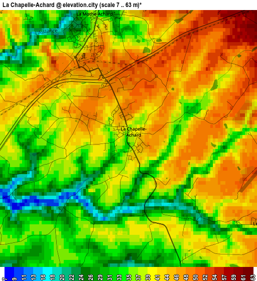
Below is the Elevation map of La Chapelle-Achard, which displays elevation range with different colors. Scale of the first map is from 7 to 63 m (23 to 207 ft) with average elevation of 39.1 meters (=128 ft) [note 1]
These maps also provides idea of topography and contour of this city, they are displayed at different zoom levels. More info about maps, scale and edge coordinates you can find below images.
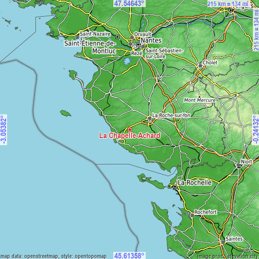
| \ | Map #1 | Topo.Map |
| Scale [m] | 7..63 m | × |
| Scale [ft] | 23..207 ft | × |
| Average | 39.1 m = 128 ft | × |
| Width | 6.72 km = 4.2 mi | 214.9 km = 133.5 mi |
| Height | 6.72 km = 4.2 mi | 214.9 km = 133.5 mi |
| ↑Max Latitude | 46.618812° | 47.54643° |
| Latitude at center | 46.58862° | 46.58862° |
| ↓Min Latitude | 46.558411° | 45.61358° |
| ← Min Longitude | -1.691515° | -3.05382° |
| Longitude center | -1.64757° | -1.64757° |
| →Max Longitude | -1.603625° | -0.24132° |
Nearby cities:
Cities around La Chapelle-Achard sort by population:
• Olonne-sur-Mer elevation 24 m
11.3 km,  238°
238°
• La Mothe-Achard 37 m
3.2 km,  343°
343°
• Nieul-le-Dolent 70 m
10.8 km,  98°
98°
• Landeronde 56 m
9.7 km,  38°
38°
• Sainte-Flaive-des-Loups 64 m
5.8 km,  61°
61°
• Beaulieu-sous-la-Roche 47 m
10.2 km,  15°
15°
• Sainte-Foy 26 m
5.2 km,  201°
201°
• Saint-Mathurin 31 m
5.7 km, 242°
• Grosbreuil 39 m
6 km,  156°
156°
• Saint-Georges-de-Pointindoux 59 m
6.5 km, 17°
• Saint-Julien-des-Landes 60 m
7.6 km,  318°
318°
• Vairé 54 m
8.4 km,  279°
279°
Multilingual:
 En español:
La Chapelle-Achard elevación 38 m.
 En France:
La Chapelle-Achard élévation 38 m.
 Auf Deutsch:
La Chapelle-Achard höhe über dem Meeresspiegel ist 38 m.

Sources and notes:
- [note 1] Map square and city borders are not equal. Map elevation data is calculated only from area inside that square.
- [src 1] Elevation data from geonames database provided with same terms of usage.
- [src 2] The elevation map of La Chapelle-Achard is generated using elevation data from NASA's 3 arcsec (90m) resolution SRTM data.
- [src 3] Base (background) map © OpenStreetMap contributors tiles are generated by Geofabrik and OpenTopoMap.
Copyright & License:
This La Chapelle-Achard Elevation Map is licensed under CC BY-SA. You may reuse any part from this page, if you give a proper credit by linking to this URL:
 More info on terms of use page.