La Côte-Saint-André elevation
La Côte-Saint-André (Auvergne-Rhône-Alpes, Département de l'Isère), France elevation is 400 meters and La Côte-Saint-André elevation in feet is 1312 ft above sea level [src 1]. La Côte-Saint-André is a populated place (feature code) with elevation that is 226 meters (741 ft) bigger than average city elevation in France.
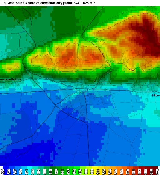
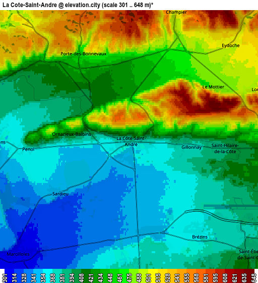
Below is the Elevation map of La Côte-Saint-André, which displays elevation range with different colors. Scale of the first map is from 324 to 628 m (1063 to 2060 ft) with average elevation of 411.8 meters (=1351 ft) [note 1]
These maps also provides idea of topography and contour of this city, they are displayed at different zoom levels. More info about maps, scale and edge coordinates you can find below images.
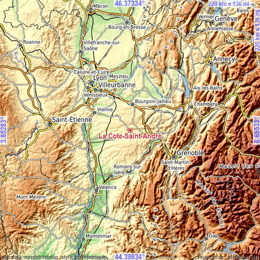
| \ | Map #1 | Map #2 | Topo.Map |
| Scale [m] | 324..628 m | 301..648 m | × |
| Scale [ft] | 1063..2060 ft | 988..2126 ft | × |
| Average | 411.8 m = 1351 ft | 422 m = 1385 ft | × |
| Width | 6.86 km = 4.3 mi | 13.73 km = 8.5 mi | 219.6 km = 136.5 mi |
| Height | 6.86 km = 4.3 mi | 13.72 km = 8.5 mi | 219.6 km = 136.5 mi |
| ↑Max Latitude | 45.425321° | 45.456155° | 46.37334° |
| Latitude at center | 45.39447° | 45.39447° | 45.39447° |
| ↓Min Latitude | 45.363602° | 45.332718° | 44.39834° |
| ← Min Longitude | 5.215135° | 5.171189° | 3.85283° |
| Longitude center | 5.25908° | 5.25908° | 5.25908° |
| →Max Longitude | 5.303025° | 5.346971° | 6.66533° |
Nearby cities:
Cities around La Côte-Saint-André sort by population:
• Saint-Siméon-de-Bressieux elevation 367 m
6.2 km,  175°
175°
• Le Grand-Lemps 468 m
12.6 km,  88°
88°
• Saint-Étienne-de-Saint-Geoirs 397 m
9.2 km,  132°
132°
• Châtonnay 488 m
11 km,  340°
340°
• Châbons 451 m
14.1 km,  67°
67°
• Sillans 406 m
11.6 km,  119°
119°
• Brézins 370 m
5.9 km,  142°
142°
• Viriville 392 m
9.8 km,  206°
206°
• Biol 464 m
14.6 km,  42°
42°
• Saint-Hilaire-de-la-Côte 400 m
4.4 km, 94°
• Champier 570 m
7.3 km,  20°
20°
• Gillonnay 411 m
2.7 km, 94°
Multilingual:
 En español:
La Côte-Saint-André elevación 400 m.
 En France:
La Côte-Saint-André élévation 400 m.
 Auf Deutsch:
La Côte-Saint-André höhe über dem Meeresspiegel ist 400 m.

Sources and notes:
- [note 1] Map square and city borders are not equal. Map elevation data is calculated only from area inside that square.
- [src 1] Elevation data from geonames database provided with same terms of usage.
- [src 2] The elevation map of La Côte-Saint-André is generated using elevation data from NASA's 3 arcsec (90m) resolution SRTM data.
- [src 3] Base (background) map © OpenStreetMap contributors tiles are generated by Geofabrik and OpenTopoMap.
Copyright & License:
This La Côte-Saint-André Elevation Map is licensed under CC BY-SA. You may reuse any part from this page, if you give a proper credit by linking to this URL:
 More info on terms of use page.