Langon elevation
Langon (Nouvelle-Aquitaine, Gironde), France elevation is 9 meters and Langon elevation in feet is 30 ft above sea level [src 1]. Langon is a seat of a third-order administrative division (feature code) with elevation that is 165 meters (541 ft) smaller than average city elevation in France.
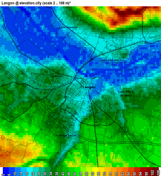
Below is the Elevation map of Langon, which displays elevation range with different colors. Scale of the first map is from 2 to 106 m (7 to 348 ft) with average elevation of 32.9 meters (=108 ft) [note 1]
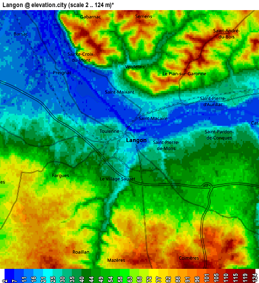
These maps also provides idea of topography and contour of this city, they are displayed at different zoom levels. More info about maps, scale and edge coordinates you can find below images.
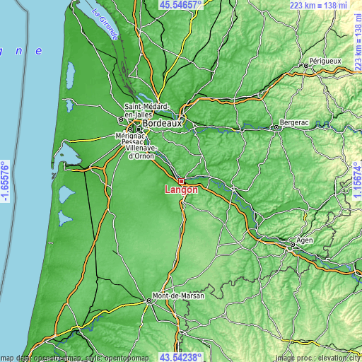
| \ | Map #1 | Map #2 | Topo.Map |
| Scale [m] | 2..106 m | 2..124 m | × |
| Scale [ft] | 7..348 ft | 7..407 ft | × |
| Average | 32.9 m = 108 ft | 51.3 m = 168 ft | × |
| Width | 6.96 km = 4.3 mi | 13.93 km = 8.7 mi | 222.8 km = 138.4 mi |
| Height | 6.96 km = 4.3 mi | 13.93 km = 8.7 mi | 222.8 km = 138.4 mi |
| ↑Max Latitude | 44.584407° | 44.615697° | 45.54657° |
| Latitude at center | 44.5531° | 44.5531° | 44.5531° |
| ↓Min Latitude | 44.521776° | 44.490435° | 43.54238° |
| ← Min Longitude | -0.293455° | -0.337401° | -1.65576° |
| Longitude center | -0.24951° | -0.24951° | -0.24951° |
| →Max Longitude | -0.205565° | -0.161619° | 1.15674° |
Nearby cities:
Cities around Langon sort by population:
• Cadillac elevation 18 m
10.7 km,  329°
329°
• Toulenne 34 m
1.2 km,  289°
289°
• Preignac 16 m
5 km,  314°
314°
• Barsac 13 m
8 km,  319°
319°
• Saint-Macaire 22 m
2.4 km,  55°
55°
• Cérons 10 m
11.3 km, 324°
• Saint-Maixant 19 m
2.9 km,  344°
344°
• Saint-Pierre-d’Aurillac 21 m
5.2 km,  66°
66°
• Castets-en-Dorthe 35 m
7.8 km,  83°
83°
• Illats 29 m
10.9 km,  296°
296°
• Noaillan 34 m
12.3 km,  228°
228°
• Loupiac 5 m
8.1 km, 330°
Multilingual:
 En español:
Langon elevación 9 m.
 En France:
Langon élévation 9 m.


Sources and notes:
- [note 1] Map square and city borders are not equal. Map elevation data is calculated only from area inside that square.
- [src 1] Elevation data from geonames database provided with same terms of usage.
- [src 2] The elevation map of Langon is generated using elevation data from NASA's 3 arcsec (90m) resolution SRTM data.
- [src 3] Base (background) map © OpenStreetMap contributors tiles are generated by Geofabrik and OpenTopoMap.
Copyright & License:
This Langon Elevation Map is licensed under CC BY-SA. You may reuse any part from this page, if you give a proper credit by linking to this URL:
 More info on terms of use page.