La Roche-Derrien elevation
La Roche-Derrien (Brittany, Département des Côtes-d’Armor), France elevation is 26 meters and La Roche-Derrien elevation in feet is 85 ft above sea level [src 1]. La Roche-Derrien is a populated place (feature code) with elevation that is 148 meters (486 ft) smaller than average city elevation in France.
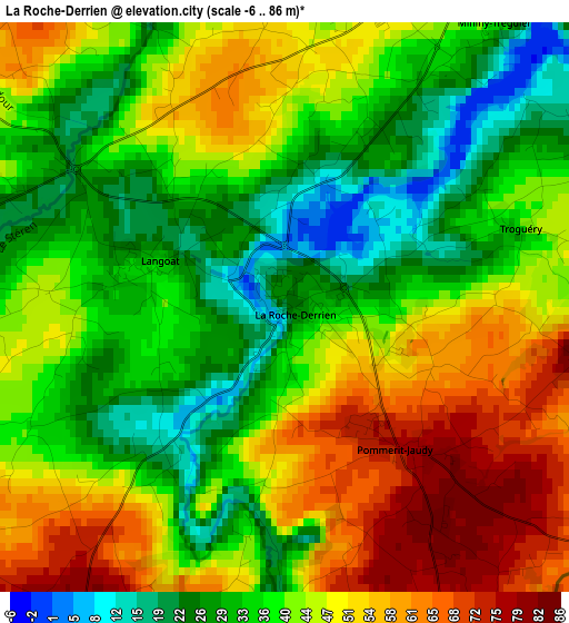
Below is the Elevation map of La Roche-Derrien, which displays elevation range with different colors. Scale of the first map is from -6 to 86 m (-20 to 282 ft) with average elevation of 41.8 meters (=137 ft) [note 1]
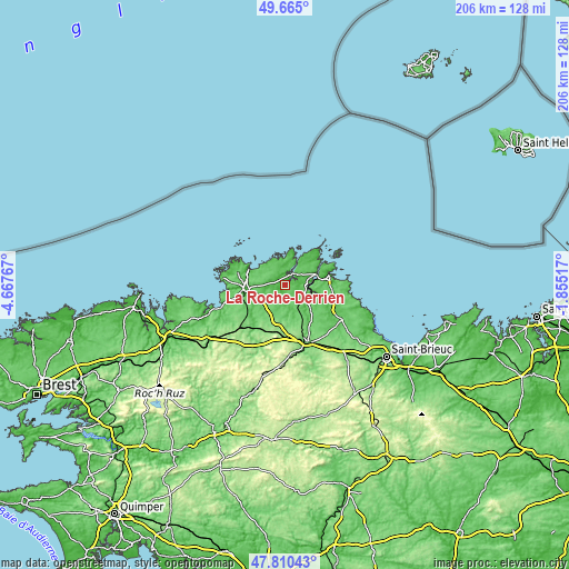
These maps also provides idea of topography and contour of this city, they are displayed at different zoom levels. More info about maps, scale and edge coordinates you can find below images.
| \ | Map #1 | Topo.Map |
| Scale [m] | -6..86 m | × |
| Scale [ft] | -20..282 ft | × |
| Average | 41.8 m = 137 ft | × |
| Width | 6.44 km = 4 mi | 206.2 km = 128.1 mi |
| Height | 6.44 km = 4 mi | 206.2 km = 128.1 mi |
| ↑Max Latitude | 48.775239° | 49.665° |
| Latitude at center | 48.74627° | 48.74627° |
| ↓Min Latitude | 48.717284° | 47.81043° |
| ← Min Longitude | -3.305365° | -4.66767° |
| Longitude center | -3.26142° | -3.26142° |
| →Max Longitude | -3.217475° | -1.85517° |
Nearby cities:
Cities around La Roche-Derrien sort by population:
• Tréguier elevation 53 m
4.6 km,  26°
26°
• Penvénan 70 m
7.7 km,  341°
341°
• Plouguiel 63 m
5.9 km,  16°
16°
• Pontrieux 9 m
9 km,  123°
123°
• Ploëzal 75 m
5.5 km,  128°
128°
• Pommerit-Jaudy 77 m
2.2 km,  140°
140°
• Plouëc-du-Trieux 85 m
8.3 km,  147°
147°
• Minihy-Tréguier 47 m
4.2 km, 34°
• Langoat 32 m
1.5 km,  288°
288°
• Trédarzec 49 m
6.2 km,  45°
45°
• Prat 80 m
8.2 km,  198°
198°
• Pleudaniel 46 m
9.2 km,  75°
75°
Multilingual:
 En español:
La Roche-Derrien elevación 26 m.
 En France:
La Roche-Derrien élévation 26 m.
 Auf Deutsch:
La Roche-Derrien höhe über dem Meeresspiegel ist 26 m.

Sources and notes:
- [note 1] Map square and city borders are not equal. Map elevation data is calculated only from area inside that square.
- [src 1] Elevation data from geonames database provided with same terms of usage.
- [src 2] The elevation map of La Roche-Derrien is generated using elevation data from NASA's 3 arcsec (90m) resolution SRTM data.
- [src 3] Base (background) map © OpenStreetMap contributors tiles are generated by Geofabrik and OpenTopoMap.
Copyright & License:
This La Roche-Derrien Elevation Map is licensed under CC BY-SA. You may reuse any part from this page, if you give a proper credit by linking to this URL:
 More info on terms of use page.