La Tour-du-Pin elevation
La Tour-du-Pin (Auvergne-Rhône-Alpes, Département de l'Isère), France elevation is 352 meters and La Tour-du-Pin elevation in feet is 1155 ft above sea level [src 1]. La Tour-du-Pin is a seat of a third-order administrative division (feature code) with elevation that is 178 meters (584 ft) bigger than average city elevation in France.
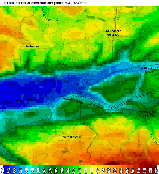
Below is the Elevation map of La Tour-du-Pin, which displays elevation range with different colors. Scale of the first map is from 304 to 537 m (997 to 1762 ft) with average elevation of 406.5 meters (=1334 ft) [note 1]
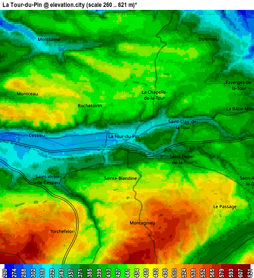
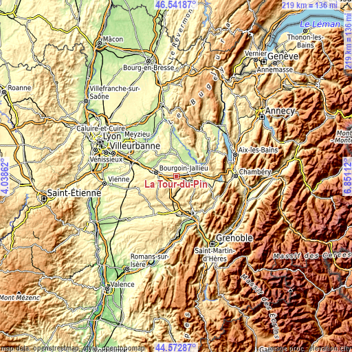
These maps also provides idea of topography and contour of this city, they are displayed at different zoom levels. More info about maps, scale and edge coordinates you can find below images.
| \ | Map #1 | Map #2 | Topo.Map |
| Scale [m] | 304..537 m | 260..621 m | × |
| Scale [ft] | 997..1762 ft | 853..2037 ft | × |
| Average | 406.5 m = 1334 ft | 425.1 m = 1395 ft | × |
| Width | 6.84 km = 4.3 mi | 13.68 km = 8.5 mi | 218.9 km = 136 mi |
| Height | 6.84 km = 4.3 mi | 13.68 km = 8.5 mi | 218.9 km = 136 mi |
| ↑Max Latitude | 45.596757° | 45.627497° | 46.54187° |
| Latitude at center | 45.566° | 45.566° | 45.566° |
| ↓Min Latitude | 45.535226° | 45.504435° | 44.57287° |
| ← Min Longitude | 5.400925° | 5.356979° | 4.03862° |
| Longitude center | 5.44487° | 5.44487° | 5.44487° |
| →Max Longitude | 5.488815° | 5.532761° | 6.85112° |
Nearby cities:
Cities around La Tour-du-Pin sort by population:
• Saint-Clair-de-la-Tour elevation 391 m
2.7 km,  71°
71°
• Dolomieu 414 m
5.4 km,  35°
35°
• Cessieu 310 m
5.4 km,  267°
267°
• Saint-André-le-Gaz 392 m
6.9 km,  109°
109°
• Corbelin 297 m
8.9 km,  58°
58°
• Saint-Victor-de-Cessieu 440 m
5 km,  236°
236°
• Curtin 255 m
9.3 km,  22°
22°
• La Chapelle-de-la-Tour 430 m
2.6 km,  34°
34°
• La Bâtie-Montgascon 368 m
6.7 km,  78°
78°
• Saint-Didier-de-la-Tour 397 m
2.9 km, 108°
• Faverges-de-la-Tour 385 m
6.6 km, 65°
• Saint-Jean-de-Soudain 343 m
1.3 km,  278°
278°
Multilingual:
 En español:
La Tour-du-Pin elevación 352 m.
 En France:
La Tour-du-Pin élévation 352 m.
 Auf Deutsch:
La Tour-du-Pin höhe über dem Meeresspiegel ist 352 m.

Sources and notes:
- [note 1] Map square and city borders are not equal. Map elevation data is calculated only from area inside that square.
- [src 1] Elevation data from geonames database provided with same terms of usage.
- [src 2] The elevation map of La Tour-du-Pin is generated using elevation data from NASA's 3 arcsec (90m) resolution SRTM data.
- [src 3] Base (background) map © OpenStreetMap contributors tiles are generated by Geofabrik and OpenTopoMap.
Copyright & License:
This La Tour-du-Pin Elevation Map is licensed under CC BY-SA. You may reuse any part from this page, if you give a proper credit by linking to this URL:
 More info on terms of use page.