Le Coteau elevation
Le Coteau (Auvergne-Rhône-Alpes, Département de la Loire), France elevation is 290 meters and Le Coteau elevation in feet is 951 ft above sea level [src 1]. Le Coteau is a populated place (feature code) with elevation that is 116 meters (381 ft) bigger than average city elevation in France.
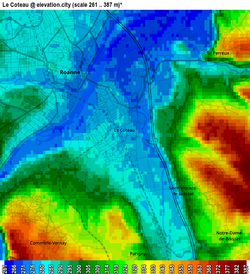
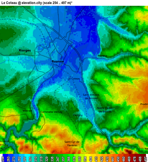
Below is the Elevation map of Le Coteau, which displays elevation range with different colors. Scale of the first map is from 261 to 387 m (856 to 1270 ft) with average elevation of 302.1 meters (=991 ft) [note 1]
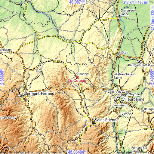
These maps also provides idea of topography and contour of this city, they are displayed at different zoom levels. More info about maps, scale and edge coordinates you can find below images.
| \ | Map #1 | Map #2 | Topo.Map |
| Scale [m] | 261..387 m | 254..497 m | × |
| Scale [ft] | 856..1270 ft | 833..1631 ft | × |
| Average | 302.1 m = 991 ft | 332.6 m = 1091 ft | × |
| Width | 6.79 km = 4.2 mi | 13.57 km = 8.4 mi | 217.2 km = 135 mi |
| Height | 6.79 km = 4.2 mi | 13.57 km = 8.4 mi | 217.1 km = 134.9 mi |
| ↑Max Latitude | 46.049698° | 46.080189° | 46.9871° |
| Latitude at center | 46.01919° | 46.01919° | 46.01919° |
| ↓Min Latitude | 45.988665° | 45.958124° | 45.03404° |
| ← Min Longitude | 4.048355° | 4.004409° | 2.68605° |
| Longitude center | 4.0923° | 4.0923° | 4.0923° |
| →Max Longitude | 4.136245° | 4.180191° | 5.49855° |
Nearby cities:
Cities around Le Coteau sort by population:
• Roanne elevation 270 m
2.7 km,  315°
315°
• Riorges 282 m
4.7 km,  305°
305°
• Mably 281 m
5.7 km,  333°
333°
• Villerest 293 m
5.2 km,  239°
239°
• Commelle 325 m
3.3 km,  232°
232°
• Perreux 316 m
3.5 km,  48°
48°
• Pouilly-les-Nonains 335 m
9 km,  288°
288°
• Régny 400 m
10.1 km,  108°
108°
• Vougy 298 m
9.7 km,  11°
11°
• Lentigny 364 m
9.2 km,  252°
252°
• Ouches 321 m
8 km,  267°
267°
• Saint-Léger-sur-Roanne 324 m
7.8 km, 288°
Multilingual:
 En español:
Le Coteau elevación 290 m.
 En France:
Le Coteau élévation 290 m.
 Auf Deutsch:
Le Coteau höhe über dem Meeresspiegel ist 290 m.

Sources and notes:
- [note 1] Map square and city borders are not equal. Map elevation data is calculated only from area inside that square.
- [src 1] Elevation data from geonames database provided with same terms of usage.
- [src 2] The elevation map of Le Coteau is generated using elevation data from NASA's 3 arcsec (90m) resolution SRTM data.
- [src 3] Base (background) map © OpenStreetMap contributors tiles are generated by Geofabrik and OpenTopoMap.
Copyright & License:
This Le Coteau Elevation Map is licensed under CC BY-SA. You may reuse any part from this page, if you give a proper credit by linking to this URL:
 More info on terms of use page.