Le Mesnil-le-Roi elevation
Le Mesnil-le-Roi (Île-de-France, Yvelines), France elevation is 60 meters and Le Mesnil-le-Roi elevation in feet is 197 ft above sea level [src 1]. Le Mesnil-le-Roi is a populated place (feature code) with elevation that is 114 meters (374 ft) smaller than average city elevation in France.
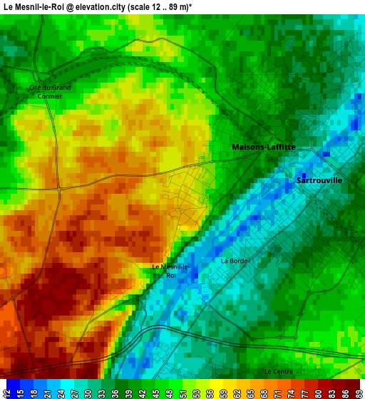
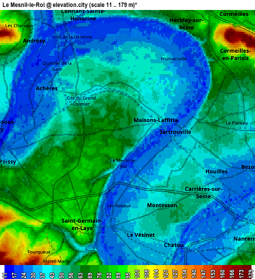
Below is the Elevation map of Le Mesnil-le-Roi, which displays elevation range with different colors. Scale of the first map is from 12 to 89 m (39 to 292 ft) with average elevation of 48.2 meters (=158 ft) [note 1]
These maps also provides idea of topography and contour of this city, they are displayed at different zoom levels. More info about maps, scale and edge coordinates you can find below images.
| \ | Map #1 | Map #2 | Topo.Map |
| Scale [m] | 12..89 m | 11..179 m | × |
| Scale [ft] | 39..292 ft | 36..587 ft | × |
| Average | 48.2 m = 158 ft | 50.5 m = 166 ft | × |
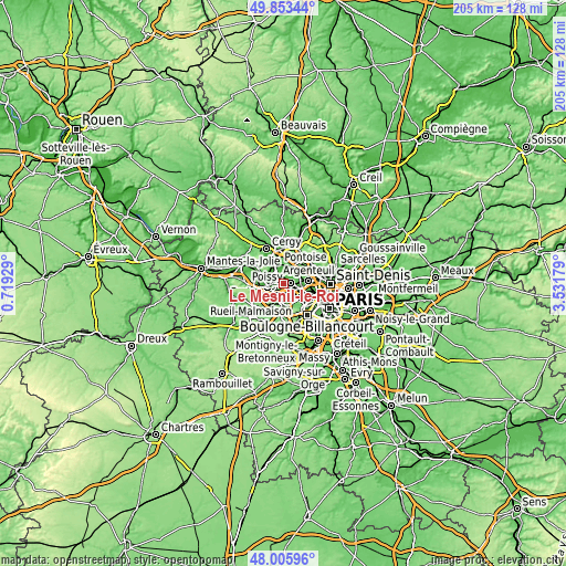
| Width | 6.42 km = 4 mi | 12.84 km = 8 mi | 205.4 km = 127.6 mi |
| Height | 6.42 km = 4 mi | 12.84 km = 8 mi | 205.4 km = 127.6 mi |
| ↑Max Latitude | 48.967108° | 48.99595° | 49.85344° |
| Latitude at center | 48.93825° | 48.93825° | 48.93825° |
| ↓Min Latitude | 48.909375° | 48.880484° | 48.00596° |
| ← Min Longitude | 2.081595° | 2.037649° | 0.71929° |
| Longitude center | 2.12554° | 2.12554° | 2.12554° |
| →Max Longitude | 2.169485° | 2.213431° | 3.53179° |
Nearby cities:
Cities around Le Mesnil-le-Roi sort by population:
• Sartrouville elevation 58 m
5 km,  77°
77°
• Saint-Germain-en-Laye 88 m
5.3 km,  208°
208°
• Poissy 31 m
5.6 km,  259°
259°
• Houilles 30 m
5.2 km,  110°
110°
• Chatou 36 m
5.9 km,  155°
155°
• Maisons-Laffitte 42 m
2.2 km,  41°
41°
• Achères 29 m
4.9 km,  301°
301°
• Le Vésinet 41 m
5.1 km,  173°
173°
• Le Pecq 34 m
5.3 km,  197°
197°
• Montesson 37 m
3.3 km, 164°
• Carrières-sur-Seine 41 m
5.2 km,  131°
131°
• Le Port-Marly 24 m
5.4 km,  190°
190°
Multilingual:
 En español:
Le Mesnil-le-Roi elevación 60 m.
 En France:
Le Mesnil-le-Roi élévation 60 m.
 Auf Deutsch:
Le Mesnil-le-Roi höhe über dem Meeresspiegel ist 60 m.

Sources and notes:
- [note 1] Map square and city borders are not equal. Map elevation data is calculated only from area inside that square.
- [src 1] Elevation data from geonames database provided with same terms of usage.
- [src 2] The elevation map of Le Mesnil-le-Roi is generated using elevation data from NASA's 3 arcsec (90m) resolution SRTM data.
- [src 3] Base (background) map © OpenStreetMap contributors tiles are generated by Geofabrik and OpenTopoMap.
Copyright & License:
This Le Mesnil-le-Roi Elevation Map is licensed under CC BY-SA. You may reuse any part from this page, if you give a proper credit by linking to this URL:
 More info on terms of use page.