Le Pin-en-Mauges elevation
Le Pin-en-Mauges (Pays de la Loire, Département de Maine-et-Loire), France elevation is 112 meters and Le Pin-en-Mauges elevation in feet is 367 ft above sea level [src 1]. Le Pin-en-Mauges is a populated place (feature code) with elevation that is 62 meters (203 ft) smaller than average city elevation in France.
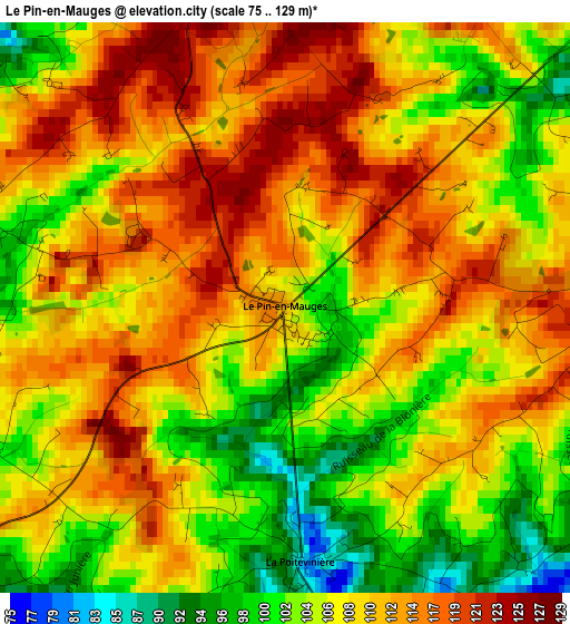
Below is the Elevation map of Le Pin-en-Mauges, which displays elevation range with different colors. Scale of the first map is from 75 to 129 m (246 to 423 ft) with average elevation of 108.7 meters (=357 ft) [note 1]
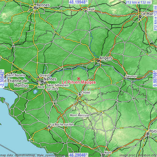
These maps also provides idea of topography and contour of this city, they are displayed at different zoom levels. More info about maps, scale and edge coordinates you can find below images.
| \ | Map #1 | Topo.Map |
| Scale [m] | 75..129 m | × |
| Scale [ft] | 246..423 ft | × |
| Average | 108.7 m = 357 ft | × |
| Width | 6.63 km = 4.1 mi | 212.3 km = 131.9 mi |
| Height | 6.63 km = 4.1 mi | 212.2 km = 131.9 mi |
| ↑Max Latitude | 47.28339° | 48.19948° |
| Latitude at center | 47.25357° | 47.25357° |
| ↓Min Latitude | 47.223733° | 46.29046° |
| ← Min Longitude | -0.943115° | -2.30542° |
| Longitude center | -0.89917° | -0.89917° |
| →Max Longitude | -0.855225° | 0.50708° |
Nearby cities:
Cities around Le Pin-en-Mauges sort by population:
• Beaupréau elevation 97 m
8.6 km,  230°
230°
• La Pommeraye 77 m
11.7 km,  14°
14°
• Saint-Pierre-Montlimart 92 m
9.8 km,  280°
280°
• Jallais 83 m
6.7 km,  159°
159°
• Andrezé 96 m
10 km,  203°
203°
• Saint-Laurent-de-la-Plaine 79 m
10.1 km,  45°
45°
• Chaudron-en-Mauges 76 m
7.6 km,  300°
300°
• Le Fief-Sauvin 85 m
11.4 km,  251°
251°
• Montrevault 57 m
11.2 km,  273°
273°
• La Jubaudière 105 m
9.1 km,  176°
176°
• La Salle-et-Chapelle-Aubry 111 m
5.7 km, 266°
• Saint-Quentin-en-Mauges 127 m
4.3 km,  347°
347°
Multilingual:
 En español:
Le Pin-en-Mauges elevación 112 m.
 En France:
Le Pin-en-Mauges élévation 112 m.
 Auf Deutsch:
Le Pin-en-Mauges höhe über dem Meeresspiegel ist 112 m.

Sources and notes:
- [note 1] Map square and city borders are not equal. Map elevation data is calculated only from area inside that square.
- [src 1] Elevation data from geonames database provided with same terms of usage.
- [src 2] The elevation map of Le Pin-en-Mauges is generated using elevation data from NASA's 3 arcsec (90m) resolution SRTM data.
- [src 3] Base (background) map © OpenStreetMap contributors tiles are generated by Geofabrik and OpenTopoMap.
Copyright & License:
This Le Pin-en-Mauges Elevation Map is licensed under CC BY-SA. You may reuse any part from this page, if you give a proper credit by linking to this URL:
 More info on terms of use page.