Le Relecq-Kerhuon elevation
Le Relecq-Kerhuon (Brittany, Département du Finistère), France elevation is 37 meters and Le Relecq-Kerhuon elevation in feet is 121 ft above sea level [src 1]. Le Relecq-Kerhuon is a populated place (feature code) with elevation that is 137 meters (449 ft) smaller than average city elevation in France.
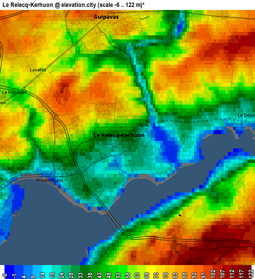
Below is the Elevation map of Le Relecq-Kerhuon, which displays elevation range with different colors. Scale of the first map is from -6 to 122 m (-20 to 400 ft) with average elevation of 59.6 meters (=196 ft) [note 1]
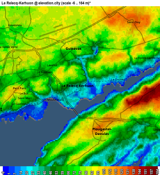
These maps also provides idea of topography and contour of this city, they are displayed at different zoom levels. More info about maps, scale and edge coordinates you can find below images.
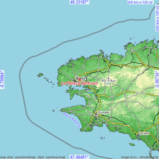
| \ | Map #1 | Map #2 | Topo.Map |
| Scale [m] | -6..122 m | -6..164 m | × |
| Scale [ft] | -20..400 ft | -20..538 ft | × |
| Average | 59.6 m = 196 ft | 71.6 m = 235 ft | × |
| Width | 6.49 km = 4 mi | 12.97 km = 8.1 mi | 207.6 km = 129 mi |
| Height | 6.49 km = 4 mi | 12.97 km = 8.1 mi | 207.6 km = 129 mi |
| ↑Max Latitude | 48.436074° | 48.465221° | 49.33187° |
| Latitude at center | 48.40691° | 48.40691° | 48.40691° |
| ↓Min Latitude | 48.377729° | 48.348532° | 47.46481° |
| ← Min Longitude | -4.437535° | -4.481481° | -5.79984° |
| Longitude center | -4.39359° | -4.39359° | -4.39359° |
| →Max Longitude | -4.349645° | -4.305699° | -2.98734° |
Nearby cities:
Cities around Le Relecq-Kerhuon sort by population:
• Brest elevation 49 m
7.1 km,  254°
254°
• Guipavas 85 m
3.2 km,  355°
355°
• Plougastel-Daoulas 84 m
4.9 km,  156°
156°
• Plabennec 86 m
10.9 km,  347°
347°
• Gouesnou 87 m
7.3 km,  314°
314°
• Loperhet 82 m
7.3 km,  117°
117°
• Bohars 71 m
9.2 km,  286°
286°
• Dirinon 138 m
9.2 km,  96°
96°
• Daoulas 5 m
11.1 km, 117°
• La Forest-Landerneau 38 m
6.1 km,  69°
69°
• Saint-Thonan 86 m
9.6 km,  27°
27°
• Kersaint-Plabennec 93 m
7.4 km,  12°
12°
Multilingual:
 En español:
Le Relecq-Kerhuon elevación 37 m.
 En France:
Le Relecq-Kerhuon élévation 37 m.
 Auf Deutsch:
Le Relecq-Kerhuon höhe über dem Meeresspiegel ist 37 m.

Sources and notes:
- [note 1] Map square and city borders are not equal. Map elevation data is calculated only from area inside that square.
- [src 1] Elevation data from geonames database provided with same terms of usage.
- [src 2] The elevation map of Le Relecq-Kerhuon is generated using elevation data from NASA's 3 arcsec (90m) resolution SRTM data.
- [src 3] Base (background) map © OpenStreetMap contributors tiles are generated by Geofabrik and OpenTopoMap.
Copyright & License:
This Le Relecq-Kerhuon Elevation Map is licensed under CC BY-SA. You may reuse any part from this page, if you give a proper credit by linking to this URL:
 More info on terms of use page.