L’Escale elevation
L’Escale (Provence-Alpes-Côte d'Azur, Alpes-de-Haute-Provence), France elevation is 455 meters and L’Escale elevation in feet is 1493 ft above sea level [src 1]. L’Escale is a populated place (feature code) with elevation that is 281 meters (922 ft) bigger than average city elevation in France.
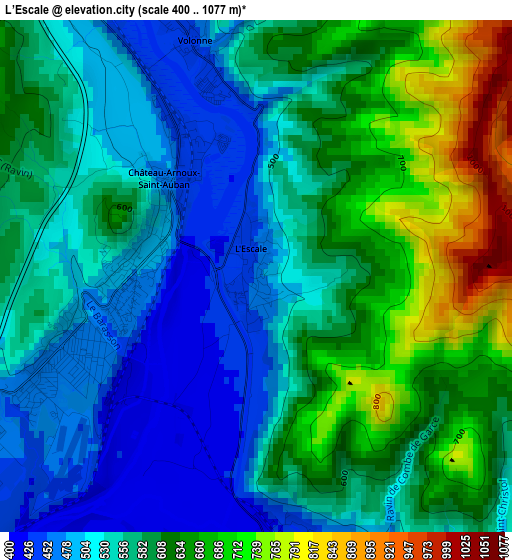
Below is the Elevation map of L’Escale, which displays elevation range with different colors. Scale of the first map is from 400 to 1077 m (1312 to 3533 ft) with average elevation of 577.9 meters (=1896 ft) [note 1]
These maps also provides idea of topography and contour of this city, they are displayed at different zoom levels. More info about maps, scale and edge coordinates you can find below images.
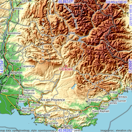
| \ | Map #1 | Topo.Map |
| Scale [m] | 400..1077 m | × |
| Scale [ft] | 1312..3533 ft | × |
| Average | 577.9 m = 1896 ft | × |
| Width | 7.02 km = 4.4 mi | 224.6 km = 139.6 mi |
| Height | 7.02 km = 4.4 mi | 224.6 km = 139.6 mi |
| ↑Max Latitude | 44.11318° | 45.08317° |
| Latitude at center | 44.08162° | 44.08162° |
| ↓Min Latitude | 44.050043° | 43.06282° |
| ← Min Longitude | 5.979845° | 4.61754° |
| Longitude center | 6.02379° | 6.02379° |
| →Max Longitude | 6.067735° | 7.43004° |
Nearby cities:
Cities around L’Escale sort by population:
• Digne-les-Bains elevation 596 m
16.7 km,  85°
85°
• Sisteron 461 m
13.5 km,  332°
332°
• Forcalquier 530 m
23.8 km,  235°
235°
• Oraison 437 m
20.1 km,  204°
204°
• Villeneuve 434 m
24.5 km,  211°
211°
• Les Mées 544 m
6.9 km, 213°
• Peyruis 390 m
8.9 km,  228°
228°
• Malijai 435 m
4 km,  172°
172°
• Volonne 454 m
3.3 km,  346°
346°
• Peipin 500 m
8.2 km,  319°
319°
• Mallemoisson 510 m
9 km,  115°
115°
• Le Brusquet 818 m
24.4 km,  68°
68°
Multilingual:
 En español:
L’Escale elevación 455 m.
 En France:
L’Escale élévation 455 m.
 Auf Deutsch:
L’Escale höhe über dem Meeresspiegel ist 455 m.

Sources and notes:
- [note 1] Map square and city borders are not equal. Map elevation data is calculated only from area inside that square.
- [src 1] Elevation data from geonames database provided with same terms of usage.
- [src 2] The elevation map of L’Escale is generated using elevation data from NASA's 3 arcsec (90m) resolution SRTM data.
- [src 3] Base (background) map © OpenStreetMap contributors tiles are generated by Geofabrik and OpenTopoMap.
Copyright & License:
This L’Escale Elevation Map is licensed under CC BY-SA. You may reuse any part from this page, if you give a proper credit by linking to this URL:
 More info on terms of use page.