Les Forges elevation
Les Forges (Grand Est, Vosges), France elevation is 371 meters and Les Forges elevation in feet is 1217 ft above sea level [src 1]. Les Forges is a populated place (feature code) with elevation that is 197 meters (646 ft) bigger than average city elevation in France.
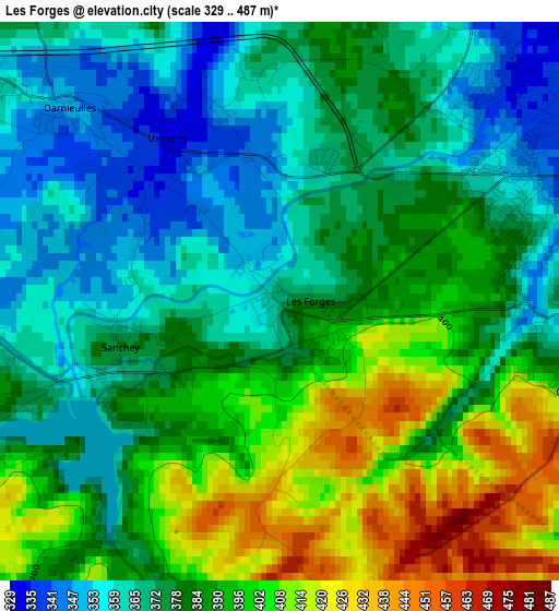
Below is the Elevation map of Les Forges, which displays elevation range with different colors. Scale of the first map is from 329 to 487 m (1079 to 1598 ft) with average elevation of 382.2 meters (=1254 ft) [note 1]
These maps also provides idea of topography and contour of this city, they are displayed at different zoom levels. More info about maps, scale and edge coordinates you can find below images.
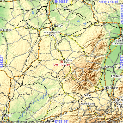
| \ | Map #1 | Topo.Map |
| Scale [m] | 329..487 m | × |
| Scale [ft] | 1079..1598 ft | × |
| Average | 382.2 m = 1254 ft | × |
| Width | 6.52 km = 4.1 mi | 208.5 km = 129.6 mi |
| Height | 6.52 km = 4.1 mi | 208.5 km = 129.6 mi |
| ↑Max Latitude | 48.206765° | 49.10663° |
| Latitude at center | 48.17747° | 48.17747° |
| ↓Min Latitude | 48.148158° | 47.23116° |
| ← Min Longitude | 6.344515° | 4.98221° |
| Longitude center | 6.38846° | 6.38846° |
| →Max Longitude | 6.432405° | 7.79471° |
Nearby cities:
Cities around Les Forges sort by population:
• Épinal elevation 365 m
4.8 km,  82°
82°
• Golbey 317 m
4.4 km,  59°
59°
• Thaon-les-Vosges 302 m
8.3 km,  14°
14°
• Chantraine 384 m
3.5 km,  100°
100°
• Uxegney 338 m
2.5 km,  326°
326°
• Dogneville 315 m
7.3 km,  46°
46°
• Chavelot 317 m
7.3 km,  30°
30°
• Deyvillers 343 m
9.7 km, 75°
• Uriménil 363 m
8.6 km,  174°
174°
• Darnieulles 355 m
3.8 km,  310°
310°
• Igney 308 m
10.7 km,  3°
3°
• Uzemain 332 m
10.7 km,  197°
197°
Multilingual:
 En español:
Les Forges elevación 371 m.
 En France:
Les Forges élévation 371 m.
 Auf Deutsch:
Les Forges höhe über dem Meeresspiegel ist 371 m.

Sources and notes:
- [note 1] Map square and city borders are not equal. Map elevation data is calculated only from area inside that square.
- [src 1] Elevation data from geonames database provided with same terms of usage.
- [src 2] The elevation map of Les Forges is generated using elevation data from NASA's 3 arcsec (90m) resolution SRTM data.
- [src 3] Base (background) map © OpenStreetMap contributors tiles are generated by Geofabrik and OpenTopoMap.
Copyright & License:
This Les Forges Elevation Map is licensed under CC BY-SA. You may reuse any part from this page, if you give a proper credit by linking to this URL:
 More info on terms of use page.