Lieu-Saint-Amand elevation
Lieu-Saint-Amand (Hauts-de-France, Nord), France elevation is 62 meters and Lieu-Saint-Amand elevation in feet is 203 ft above sea level [src 1]. Lieu-Saint-Amand is a populated place (feature code) with elevation that is 112 meters (367 ft) smaller than average city elevation in France.
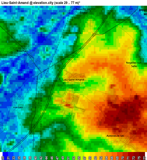
Below is the Elevation map of Lieu-Saint-Amand, which displays elevation range with different colors. Scale of the first map is from 29 to 77 m (95 to 253 ft) with average elevation of 49.1 meters (=161 ft) [note 1]
These maps also provides idea of topography and contour of this city, they are displayed at different zoom levels. More info about maps, scale and edge coordinates you can find below images.
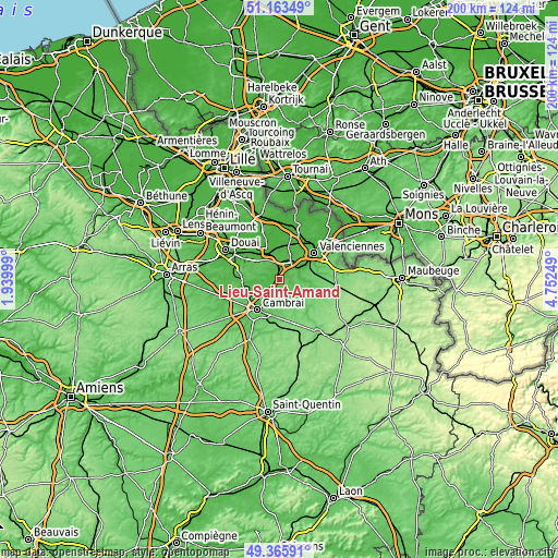
| \ | Map #1 | Topo.Map |
| Scale [m] | 29..77 m | × |
| Scale [ft] | 95..253 ft | × |
| Average | 49.1 m = 161 ft | × |
| Width | 6.25 km = 3.9 mi | 199.9 km = 124.2 mi |
| Height | 6.25 km = 3.9 mi | 199.9 km = 124.2 mi |
| ↑Max Latitude | 50.301258° | 51.16349° |
| Latitude at center | 50.27318° | 50.27318° |
| ↓Min Latitude | 50.245085° | 49.36591° |
| ← Min Longitude | 3.302295° | 1.93999° |
| Longitude center | 3.34624° | 3.34624° |
| →Max Longitude | 3.390185° | 4.75249° |
Nearby cities:
Cities around Lieu-Saint-Amand sort by population:
• Douchy-les-Mines elevation 48 m
4.5 km,  47°
47°
• Escaudain 39 m
6.7 km,  358°
358°
• Bouchain 43 m
2.6 km,  300°
300°
• Lourches 30 m
4.5 km,  5°
5°
• Rœulx 38 m
3.1 km,  342°
342°
• Iwuy 48 m
4.8 km,  202°
202°
• Haspres 44 m
5.3 km,  108°
108°
• Neuville-sur-Escaut 36 m
3 km, 5°
• Marquette-en-Ostrevant 43 m
5.8 km,  281°
281°
• Avesnes-le-Sec 65 m
3.3 km,  137°
137°
• Hordain 39 m
2.6 km,  244°
244°
• Villers-en-Cauchies 75 m
6.7 km, 142°
Multilingual:
 En español:
Lieu-Saint-Amand elevación 62 m.
 En France:
Lieu-Saint-Amand élévation 62 m.
 Auf Deutsch:
Lieu-Saint-Amand höhe über dem Meeresspiegel ist 62 m.

Sources and notes:
- [note 1] Map square and city borders are not equal. Map elevation data is calculated only from area inside that square.
- [src 1] Elevation data from geonames database provided with same terms of usage.
- [src 2] The elevation map of Lieu-Saint-Amand is generated using elevation data from NASA's 3 arcsec (90m) resolution SRTM data.
- [src 3] Base (background) map © OpenStreetMap contributors tiles are generated by Geofabrik and OpenTopoMap.
Copyright & License:
This Lieu-Saint-Amand Elevation Map is licensed under CC BY-SA. You may reuse any part from this page, if you give a proper credit by linking to this URL:
 More info on terms of use page.