Ligny-le-Ribault elevation
Ligny-le-Ribault (Centre, Loiret), France elevation is 95 meters and Ligny-le-Ribault elevation in feet is 312 ft above sea level [src 1]. Ligny-le-Ribault is a populated place (feature code) with elevation that is 79 meters (259 ft) smaller than average city elevation in France.
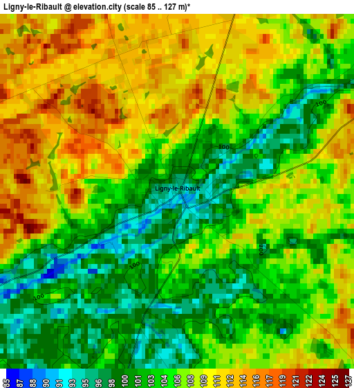
Below is the Elevation map of Ligny-le-Ribault, which displays elevation range with different colors. Scale of the first map is from 85 to 127 m (279 to 417 ft) with average elevation of 106 meters (=348 ft) [note 1]
These maps also provides idea of topography and contour of this city, they are displayed at different zoom levels. More info about maps, scale and edge coordinates you can find below images.
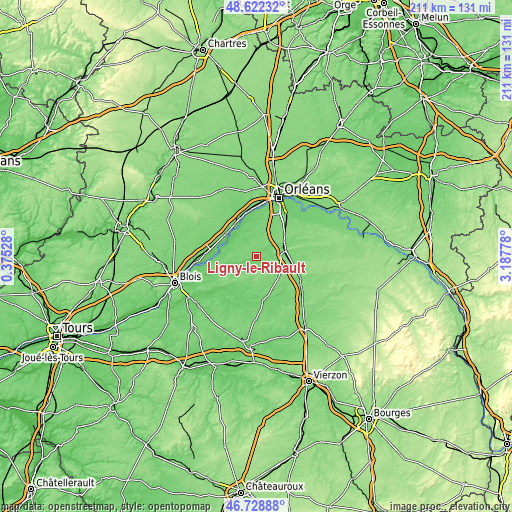
| \ | Map #1 | Topo.Map |
| Scale [m] | 85..127 m | × |
| Scale [ft] | 279..417 ft | × |
| Average | 106 m = 348 ft | × |
| Width | 6.58 km = 4.1 mi | 210.5 km = 130.8 mi |
| Height | 6.58 km = 4.1 mi | 210.5 km = 130.8 mi |
| ↑Max Latitude | 47.713766° | 48.62232° |
| Latitude at center | 47.68419° | 47.68419° |
| ↓Min Latitude | 47.654597° | 46.72888° |
| ← Min Longitude | 1.737585° | 0.37528° |
| Longitude center | 1.78153° | 1.78153° |
| →Max Longitude | 1.825475° | 3.18778° |
Nearby cities:
Cities around Ligny-le-Ribault sort by population:
• Beaugency elevation 101 m
15.7 km,  312°
312°
• La Ferté-Saint-Aubin 107 m
12.3 km,  72°
72°
• Saint-Laurent-Nouan 78 m
14.1 km,  284°
284°
• Cléry-Saint-André 90 m
15.5 km,  351°
351°
• Lailly-en-Val 86 m
11.9 km,  323°
323°
• Baule 104 m
16.3 km,  329°
329°
• Jouy-le-Potier 115 m
7.2 km,  17°
17°
• Dhuizon 111 m
14.2 km,  220°
220°
• Tavers 98 m
15.1 km,  303°
303°
• Dry 91 m
13.5 km,  337°
337°
• Neung-sur-Beuvron 99 m
16.7 km,  173°
173°
• Chaumont-sur-Tharonne 133 m
12.4 km,  131°
131°
Multilingual:
 En español:
Ligny-le-Ribault elevación 95 m.
 En France:
Ligny-le-Ribault élévation 95 m.
 Auf Deutsch:
Ligny-le-Ribault höhe über dem Meeresspiegel ist 95 m.

Sources and notes:
- [note 1] Map square and city borders are not equal. Map elevation data is calculated only from area inside that square.
- [src 1] Elevation data from geonames database provided with same terms of usage.
- [src 2] The elevation map of Ligny-le-Ribault is generated using elevation data from NASA's 3 arcsec (90m) resolution SRTM data.
- [src 3] Base (background) map © OpenStreetMap contributors tiles are generated by Geofabrik and OpenTopoMap.
Copyright & License:
This Ligny-le-Ribault Elevation Map is licensed under CC BY-SA. You may reuse any part from this page, if you give a proper credit by linking to this URL:
 More info on terms of use page.