Longpont-sur-Orge elevation
Longpont-sur-Orge (Île-de-France, Département de l'Essonne), France elevation is 59 meters and Longpont-sur-Orge elevation in feet is 194 ft above sea level [src 1]. Longpont-sur-Orge is a populated place (feature code) with elevation that is 115 meters (377 ft) smaller than average city elevation in France.
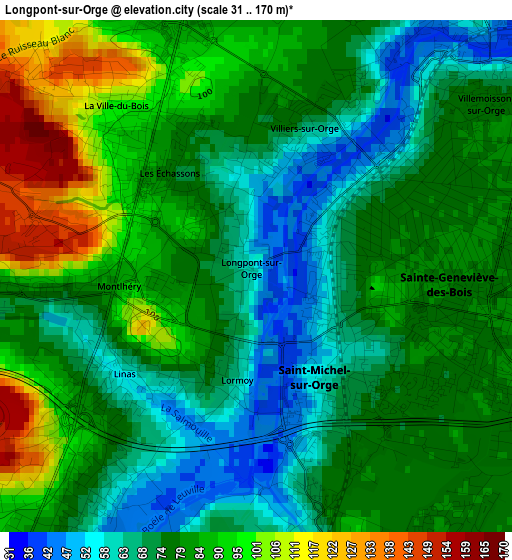
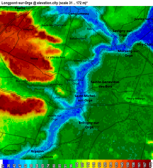
Below is the Elevation map of Longpont-sur-Orge, which displays elevation range with different colors. Scale of the first map is from 31 to 170 m (102 to 558 ft) with average elevation of 79 meters (=259 ft) [note 1]
These maps also provides idea of topography and contour of this city, they are displayed at different zoom levels. More info about maps, scale and edge coordinates you can find below images.
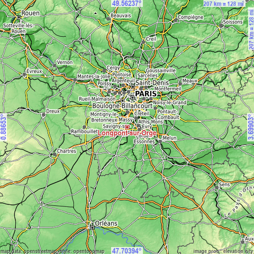
| \ | Map #1 | Map #2 | Topo.Map |
| Scale [m] | 31..170 m | 31..172 m | × |
| Scale [ft] | 102..558 ft | 102..564 ft | × |
| Average | 79 m = 259 ft | 88.1 m = 289 ft | × |
| Width | 6.46 km = 4 mi | 12.91 km = 8 mi | 206.6 km = 128.4 mi |
| Height | 6.46 km = 4 mi | 12.91 km = 8 mi | 206.6 km = 128.4 mi |
| ↑Max Latitude | 48.670739° | 48.699752° | 49.56237° |
| Latitude at center | 48.64171° | 48.64171° | 48.64171° |
| ↓Min Latitude | 48.612664° | 48.583601° | 47.70394° |
| ← Min Longitude | 2.248835° | 2.204889° | 0.88653° |
| Longitude center | 2.29278° | 2.29278° | 2.29278° |
| →Max Longitude | 2.336725° | 2.380671° | 3.69903° |
Nearby cities:
Cities around Longpont-sur-Orge sort by population:
• Sainte-Geneviève-des-Bois elevation 79 m
2.1 km,  73°
73°
• Brétigny-sur-Orge 69 m
3.5 km,  164°
164°
• Saint-Michel-sur-Orge 66 m
1.4 km,  123°
123°
• Épinay-sur-Orge 86 m
3.8 km,  20°
20°
• Marcoussis 78 m
4 km,  267°
267°
• Montlhéry 83 m
1.3 km,  262°
262°
• La Ville-du-Bois 95 m
2.3 km,  309°
309°
• Linas 74 m
2.5 km,  240°
240°
• Le Plessis-Pâté 78 m
4.1 km,  146°
146°
• Villiers-sur-Orge 74 m
2.1 km, 15°
• Leuville-sur-Orge 67 m
3.3 km,  215°
215°
• Ballainvilliers 72 m
3.7 km,  8°
8°
Multilingual:
 En español:
Longpont-sur-Orge elevación 59 m.
 En France:
Longpont-sur-Orge élévation 59 m.
 Auf Deutsch:
Longpont-sur-Orge höhe über dem Meeresspiegel ist 59 m.

Sources and notes:
- [note 1] Map square and city borders are not equal. Map elevation data is calculated only from area inside that square.
- [src 1] Elevation data from geonames database provided with same terms of usage.
- [src 2] The elevation map of Longpont-sur-Orge is generated using elevation data from NASA's 3 arcsec (90m) resolution SRTM data.
- [src 3] Base (background) map © OpenStreetMap contributors tiles are generated by Geofabrik and OpenTopoMap.
Copyright & License:
This Longpont-sur-Orge Elevation Map is licensed under CC BY-SA. You may reuse any part from this page, if you give a proper credit by linking to this URL:
 More info on terms of use page.