Luz-Saint-Sauveur elevation
Luz-Saint-Sauveur (Occitanie, Département des Hautes-Pyrénées), France elevation is 723 meters and Luz-Saint-Sauveur elevation in feet is 2372 ft above sea level [src 1]. Luz-Saint-Sauveur is a populated place (feature code) with elevation that is 549 meters (1801 ft) bigger than average city elevation in France.
Below is the Elevation map of Luz-Saint-Sauveur, which displays elevation range with different colors. Scale of the first map is from 616 to 2449 m (2021 to 8035 ft) with average elevation of 1321.2 meters (=4335 ft) [note 1]
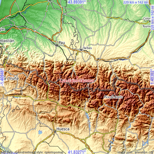
These maps also provides idea of topography and contour of this city, they are displayed at different zoom levels. More info about maps, scale and edge coordinates you can find below images.
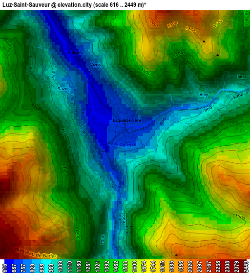
| \ | Map #1 | Topo.Map |
| Scale [m] | 616..2449 m | × |
| Scale [ft] | 2021..8035 ft | × |
| Average | 1321.2 m = 4335 ft | × |
| Width | 7.16 km = 4.4 mi | 229.2 km = 142.4 mi |
| Height | 7.16 km = 4.4 mi | 229.2 km = 142.4 mi |
| ↑Max Latitude | 42.904108° | 43.89391° |
| Latitude at center | 42.87191° | 42.87191° |
| ↓Min Latitude | 42.839695° | 41.83271° |
| ← Min Longitude | -0.047175° | -1.40948° |
| Longitude center | -0.00323° | -0.00323° |
| →Max Longitude | 0.040715° | 1.40302° |
Nearby cities:
Cities around Luz-Saint-Sauveur sort by population:
• Lourdes elevation 416 m
25.6 km,  351°
351°
• Bagnères-de-Bigorre 560 m
24.7 km,  30°
30°
• Argelès-Gazost 428 m
16.5 km,  331°
331°
• Campan 662 m
21.8 km,  42°
42°
• Saint-Pé-de-Bigorre 359 m
28.7 km, 333°
• Pierrefitte-Nestalas 460 m
11.7 km, 333°
• Gerde 584 m
24.7 km, 34°
• Pouzac 507 m
26.3 km, 25°
• Lestelle-Bétharram 296 m
33.9 km, 329°
• Cauterets 1135 m
9.3 km,  277°
277°
• Montaut 316 m
33.2 km, 331°
• Saint-Lary-Soulan 820 m
27.2 km,  102°
102°
Multilingual:
 En español:
Luz-Saint-Sauveur elevación 723 m.
 En France:
Luz-Saint-Sauveur élévation 723 m.
 Auf Deutsch:
Luz-Saint-Sauveur höhe über dem Meeresspiegel ist 723 m.

Sources and notes:
- [note 1] Map square and city borders are not equal. Map elevation data is calculated only from area inside that square.
- [src 1] Elevation data from geonames database provided with same terms of usage.
- [src 2] The elevation map of Luz-Saint-Sauveur is generated using elevation data from NASA's 3 arcsec (90m) resolution SRTM data.
- [src 3] Base (background) map © OpenStreetMap contributors tiles are generated by Geofabrik and OpenTopoMap.
Copyright & License:
This Luz-Saint-Sauveur Elevation Map is licensed under CC BY-SA. You may reuse any part from this page, if you give a proper credit by linking to this URL:
 More info on terms of use page.