Marvejols elevation
Marvejols (Occitanie, Département de la Lozère), France elevation is 658 meters and Marvejols elevation in feet is 2159 ft above sea level [src 1]. Marvejols is a populated place (feature code) with elevation that is 484 meters (1588 ft) bigger than average city elevation in France.
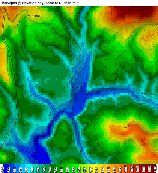
Below is the Elevation map of Marvejols, which displays elevation range with different colors. Scale of the first map is from 614 to 1101 m (2014 to 3612 ft) with average elevation of 792.5 meters (=2600 ft) [note 1]
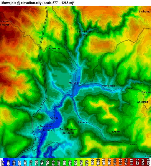
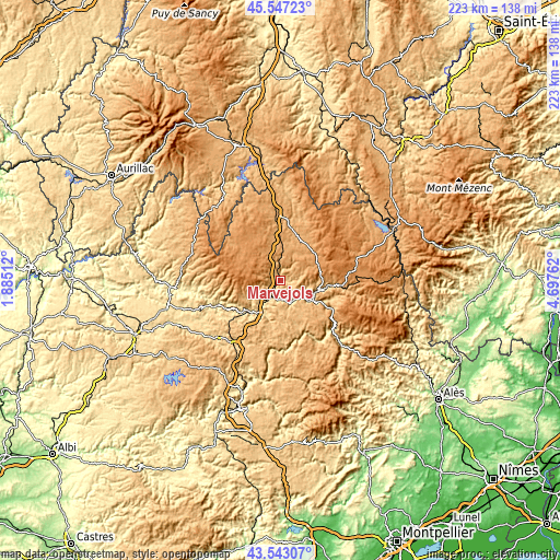
These maps also provides idea of topography and contour of this city, they are displayed at different zoom levels. More info about maps, scale and edge coordinates you can find below images.
| \ | Map #1 | Map #2 | Topo.Map |
| Scale [m] | 614..1101 m | 577..1268 m | × |
| Scale [ft] | 2014..3612 ft | 1893..4160 ft | × |
| Average | 792.5 m = 2600 ft | 886.7 m = 2909 ft | × |
| Width | 6.96 km = 4.3 mi | 13.93 km = 8.7 mi | 222.8 km = 138.4 mi |
| Height | 6.96 km = 4.3 mi | 13.93 km = 8.7 mi | 222.8 km = 138.4 mi |
| ↑Max Latitude | 44.585087° | 44.616376° | 45.54723° |
| Latitude at center | 44.55378° | 44.55378° | 44.55378° |
| ↓Min Latitude | 44.522456° | 44.491116° | 43.54307° |
| ← Min Longitude | 3.247425° | 3.203479° | 1.88512° |
| Longitude center | 3.29137° | 3.29137° | 3.29137° |
| →Max Longitude | 3.335315° | 3.379261° | 4.69762° |
Nearby cities:
Cities around Marvejols sort by population:
• Mende elevation 761 m
17.3 km,  103°
103°
• Sévérac-le-Château 681 m
31.5 km,  215°
215°
• La Canourgue 565 m
14.9 km,  203°
203°
• Saint-Geniez-d’Olt 431 m
27.1 km,  248°
248°
• Florac 804 m
34.8 km,  136°
136°
• Saint-Alban-sur-Limagnole 971 m
26.4 km,  16°
16°
• Laguiole 1008 m
38.1 km,  292°
292°
• Chanac 666 m
10.6 km,  157°
157°
• Aumont-Aubrac 1059 m
18.7 km,  358°
358°
• Chirac 636 m
4 km,  209°
209°
• Montrodat 741 m
3 km, 97°
• Le Malzieu-Ville 868 m
33.9 km,  5°
5°
Multilingual:
 En español:
Marvejols elevación 658 m.
 En France:
Marvejols élévation 658 m.
 Auf Deutsch:
Marvejols höhe über dem Meeresspiegel ist 658 m.

Sources and notes:
- [note 1] Map square and city borders are not equal. Map elevation data is calculated only from area inside that square.
- [src 1] Elevation data from geonames database provided with same terms of usage.
- [src 2] The elevation map of Marvejols is generated using elevation data from NASA's 3 arcsec (90m) resolution SRTM data.
- [src 3] Base (background) map © OpenStreetMap contributors tiles are generated by Geofabrik and OpenTopoMap.
Copyright & License:
This Marvejols Elevation Map is licensed under CC BY-SA. You may reuse any part from this page, if you give a proper credit by linking to this URL:
 More info on terms of use page.