Matour elevation
Matour (Bourgogne-Franche-Comté, Département de Saône-et-Loire), France elevation is 431 meters and Matour elevation in feet is 1414 ft above sea level [src 1]. Matour is a populated place (feature code) with elevation that is 257 meters (843 ft) bigger than average city elevation in France.
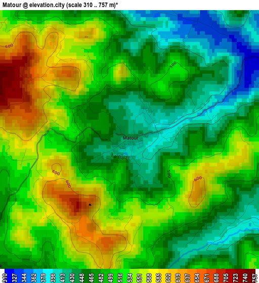
Below is the Elevation map of Matour, which displays elevation range with different colors. Scale of the first map is from 310 to 757 m (1017 to 2484 ft) with average elevation of 501.3 meters (=1645 ft) [note 1]
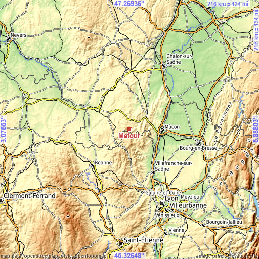
These maps also provides idea of topography and contour of this city, they are displayed at different zoom levels. More info about maps, scale and edge coordinates you can find below images.
| \ | Map #1 | Topo.Map |
| Scale [m] | 310..757 m | × |
| Scale [ft] | 1017..2484 ft | × |
| Average | 501.3 m = 1645 ft | × |
| Width | 6.75 km = 4.2 mi | 216 km = 134.2 mi |
| Height | 6.75 km = 4.2 mi | 216 km = 134.2 mi |
| ↑Max Latitude | 46.336889° | 47.26936° |
| Latitude at center | 46.30654° | 46.30654° |
| ↓Min Latitude | 46.276174° | 45.32648° |
| ← Min Longitude | 4.437835° | 3.07553° |
| Longitude center | 4.48178° | 4.48178° |
| →Max Longitude | 4.525725° | 5.88803° |
Nearby cities:
Cities around Matour sort by population:
• Charnay-lès-Mâcon elevation 257 m
23.3 km,  89°
89°
• Cluny 244 m
19.5 km,  43°
43°
• Chauffailles 405 m
15.6 km,  224°
224°
• Charolles 287 m
21.3 km,  311°
311°
• La Clayette 389 m
13.8 km,  262°
262°
• Beaujeu 343 m
18.8 km,  154°
154°
• Villié-Morgon 282 m
22.2 km,  136°
136°
• Prissé 207 m
20.3 km, 85°
• Belmont-de-la-Loire 527 m
18.7 km,  213°
213°
• La Roche-Vineuse 230 m
18.8 km,  76°
76°
• Fleurie 298 m
20.9 km,  127°
127°
• Quincié-en-Beaujolais 292 m
23.3 km, 153°
Multilingual:
 En español:
Matour elevación 431 m.
 En France:
Matour élévation 431 m.


Sources and notes:
- [note 1] Map square and city borders are not equal. Map elevation data is calculated only from area inside that square.
- [src 1] Elevation data from geonames database provided with same terms of usage.
- [src 2] The elevation map of Matour is generated using elevation data from NASA's 3 arcsec (90m) resolution SRTM data.
- [src 3] Base (background) map © OpenStreetMap contributors tiles are generated by Geofabrik and OpenTopoMap.
Copyright & License:
This Matour Elevation Map is licensed under CC BY-SA. You may reuse any part from this page, if you give a proper credit by linking to this URL:
 More info on terms of use page.