Méréville elevation
Méréville (Île-de-France, Département de l'Essonne), France elevation is 113 meters and Méréville elevation in feet is 371 ft above sea level [src 1]. Méréville is a populated place (feature code) with elevation that is 61 meters (200 ft) smaller than average city elevation in France.
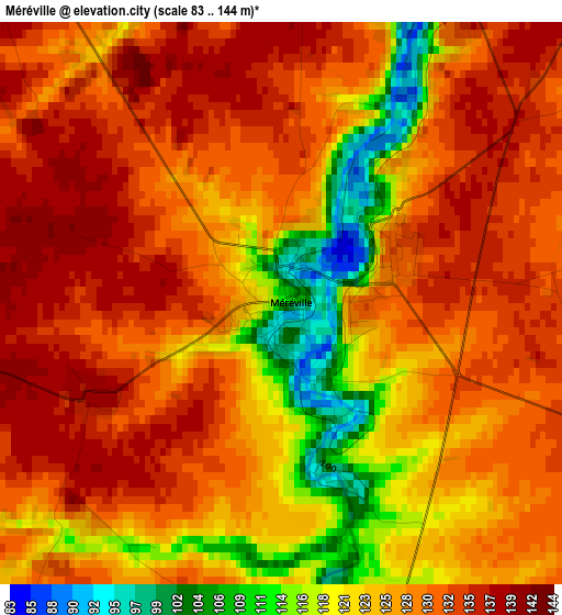
Below is the Elevation map of Méréville, which displays elevation range with different colors. Scale of the first map is from 83 to 144 m (272 to 472 ft) with average elevation of 127.2 meters (=417 ft) [note 1]
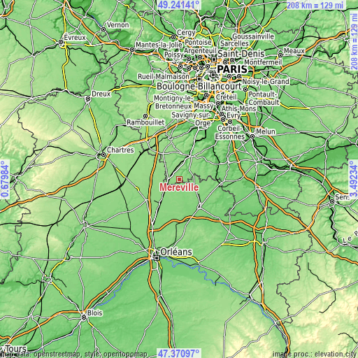
These maps also provides idea of topography and contour of this city, they are displayed at different zoom levels. More info about maps, scale and edge coordinates you can find below images.
| \ | Map #1 | Topo.Map |
| Scale [m] | 83..144 m | × |
| Scale [ft] | 272..472 ft | × |
| Average | 127.2 m = 417 ft | × |
| Width | 6.5 km = 4 mi | 208 km = 129.2 mi |
| Height | 6.5 km = 4 mi | 208 km = 129.2 mi |
| ↑Max Latitude | 48.343977° | 49.24141° |
| Latitude at center | 48.31476° | 48.31476° |
| ↓Min Latitude | 48.285526° | 47.37097° |
| ← Min Longitude | 2.042145° | 0.67984° |
| Longitude center | 2.08609° | 2.08609° |
| →Max Longitude | 2.130035° | 3.49234° |
Nearby cities:
Cities around Méréville sort by population:
• Étampes elevation 70 m
14.5 km,  22°
22°
• Morigny-Champigny 71 m
16.4 km,  26°
26°
• Angerville 142 m
6.4 km,  268°
268°
• Toury 135 m
17.5 km,  219°
219°
• Pithiviers-le-Vieil 120 m
19.2 km,  151°
151°
• Saclas 80 m
5.6 km, 29°
• Janville 134 m
19.7 km,  230°
230°
• Pussay 147 m
7.9 km,  298°
298°
• Sermaises 123 m
9.1 km,  102°
102°
• Outarville 133 m
12.2 km,  202°
202°
• Bazoches-les-Gallerandes 129 m
16.9 km,  190°
190°
• Chalo-Saint-Mars 94 m
12.2 km,  352°
352°
Multilingual:
 En español:
Méréville elevación 113 m.
 En France:
Méréville élévation 113 m.
 Auf Deutsch:
Méréville höhe über dem Meeresspiegel ist 113 m.

Sources and notes:
- [note 1] Map square and city borders are not equal. Map elevation data is calculated only from area inside that square.
- [src 1] Elevation data from geonames database provided with same terms of usage.
- [src 2] The elevation map of Méréville is generated using elevation data from NASA's 3 arcsec (90m) resolution SRTM data.
- [src 3] Base (background) map © OpenStreetMap contributors tiles are generated by Geofabrik and OpenTopoMap.
Copyright & License:
This Méréville Elevation Map is licensed under CC BY-SA. You may reuse any part from this page, if you give a proper credit by linking to this URL:
 More info on terms of use page.