Metzeral elevation
Metzeral (Grand Est, Haut-Rhin), France elevation is 568 meters and Metzeral elevation in feet is 1864 ft above sea level [src 1]. Metzeral is a populated place (feature code) with elevation that is 394 meters (1293 ft) bigger than average city elevation in France.
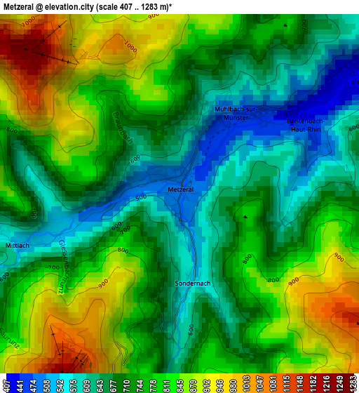
Below is the Elevation map of Metzeral, which displays elevation range with different colors. Scale of the first map is from 407 to 1283 m (1335 to 4209 ft) with average elevation of 747.4 meters (=2452 ft) [note 1]
These maps also provides idea of topography and contour of this city, they are displayed at different zoom levels. More info about maps, scale and edge coordinates you can find below images.
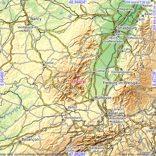
| \ | Map #1 | Topo.Map |
| Scale [m] | 407..1283 m | × |
| Scale [ft] | 1335..4209 ft | × |
| Average | 747.4 m = 2452 ft | × |
| Width | 6.54 km = 4.1 mi | 209.2 km = 130 mi |
| Height | 6.54 km = 4.1 mi | 209.2 km = 130 mi |
| ↑Max Latitude | 48.04156° | 48.94434° |
| Latitude at center | 48.01217° | 48.01217° |
| ↓Min Latitude | 47.982763° | 47.06284° |
| ← Min Longitude | 7.026965° | 5.66466° |
| Longitude center | 7.07091° | 7.07091° |
| →Max Longitude | 7.114855° | 8.47716° |
Nearby cities:
Cities around Metzeral sort by population:
• Munster elevation 399 m
6 km,  58°
58°
• Buhl 341 m
12.7 km,  137°
137°
• Soultzmatt 258 m
13.6 km,  114°
114°
• Labaroche 758 m
14.2 km,  39°
39°
• Lautenbach 395 m
10.3 km, 140°
• Xonrupt-Longemer 719 m
13.1 km,  306°
306°
• Oderen 467 m
13.4 km,  212°
212°
• Stosswihr 466 m
5.1 km,  24°
24°
• Wihr-au-Val 306 m
10.9 km,  66°
66°
• Soultzeren 614 m
6.2 km, 22°
• Kruth 493 m
12 km,  221°
221°
• Lautenbachzell 427 m
9.7 km, 144°
Multilingual:
 En español:
Metzeral elevación 568 m.
 En France:
Metzeral élévation 568 m.
 Auf Deutsch:
Metzeral höhe über dem Meeresspiegel ist 568 m.

Sources and notes:
- [note 1] Map square and city borders are not equal. Map elevation data is calculated only from area inside that square.
- [src 1] Elevation data from geonames database provided with same terms of usage.
- [src 2] The elevation map of Metzeral is generated using elevation data from NASA's 3 arcsec (90m) resolution SRTM data.
- [src 3] Base (background) map © OpenStreetMap contributors tiles are generated by Geofabrik and OpenTopoMap.
Copyright & License:
This Metzeral Elevation Map is licensed under CC BY-SA. You may reuse any part from this page, if you give a proper credit by linking to this URL:
 More info on terms of use page.