Meulan-en-Yvelines elevation
Meulan-en-Yvelines (Île-de-France, Yvelines), France elevation is 28 meters and Meulan-en-Yvelines elevation in feet is 92 ft above sea level [src 1]. Meulan-en-Yvelines is a populated place (feature code) with elevation that is 146 meters (479 ft) smaller than average city elevation in France.
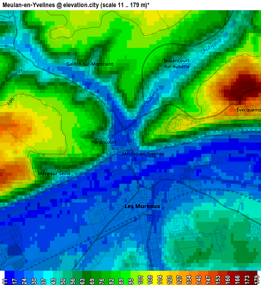
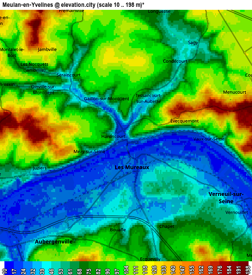
Below is the Elevation map of Meulan-en-Yvelines, which displays elevation range with different colors. Scale of the first map is from 11 to 179 m (36 to 587 ft) with average elevation of 59.2 meters (=194 ft) [note 1]
These maps also provides idea of topography and contour of this city, they are displayed at different zoom levels. More info about maps, scale and edge coordinates you can find below images.
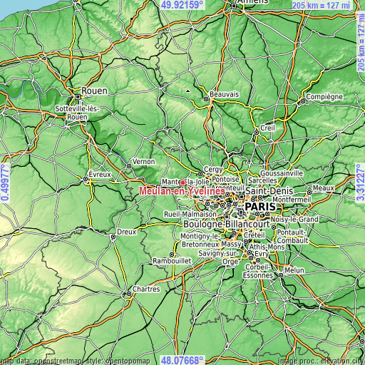
| \ | Map #1 | Map #2 | Topo.Map |
| Scale [m] | 11..179 m | 10..198 m | × |
| Scale [ft] | 36..587 ft | 33..650 ft | × |
| Average | 59.2 m = 194 ft | 77.4 m = 254 ft | × |
| Width | 6.41 km = 4 mi | 12.82 km = 8 mi | 205.1 km = 127.4 mi |
| Height | 6.41 km = 4 mi | 12.82 km = 8 mi | 205.1 km = 127.4 mi |
| ↑Max Latitude | 49.036498° | 49.065299° | 49.92159° |
| Latitude at center | 49.00768° | 49.00768° | 49.00768° |
| ↓Min Latitude | 48.978845° | 48.949994° | 48.07668° |
| ← Min Longitude | 1.862075° | 1.818129° | 0.49977° |
| Longitude center | 1.90602° | 1.90602° | 1.90602° |
| →Max Longitude | 1.949965° | 1.993911° | 3.31227° |
Nearby cities:
Cities around Meulan-en-Yvelines sort by population:
• Les Mureaux elevation 25 m
1.8 km,  171°
171°
• Verneuil-sur-Seine 60 m
5.7 km,  131°
131°
• Vaux-sur-Seine 117 m
4.7 km,  83°
83°
• Juziers 43 m
4.6 km,  246°
246°
• Flins-sur-Seine 42 m
5.3 km,  206°
206°
• Bouafle 69 m
4.8 km,  184°
184°
• Hardricourt 61 m
0.9 km,  270°
270°
• Mézy-sur-Seine 40 m
1.9 km,  242°
242°
• Seraincourt 40 m
4.2 km,  317°
317°
• Sagy 51 m
5.8 km,  35°
35°
• Chapet 68 m
5 km,  156°
156°
• Oinville-sur-Montcient 74 m
4.7 km,  297°
297°
Multilingual:
 En español:
Meulan-en-Yvelines elevación 28 m.
 En France:
Meulan-en-Yvelines élévation 28 m.
 Auf Deutsch:
Meulan-en-Yvelines höhe über dem Meeresspiegel ist 28 m.

Sources and notes:
- [note 1] Map square and city borders are not equal. Map elevation data is calculated only from area inside that square.
- [src 1] Elevation data from geonames database provided with same terms of usage.
- [src 2] The elevation map of Meulan-en-Yvelines is generated using elevation data from NASA's 3 arcsec (90m) resolution SRTM data.
- [src 3] Base (background) map © OpenStreetMap contributors tiles are generated by Geofabrik and OpenTopoMap.
Copyright & License:
This Meulan-en-Yvelines Elevation Map is licensed under CC BY-SA. You may reuse any part from this page, if you give a proper credit by linking to this URL:
 More info on terms of use page.