Montauban elevation
Montauban (Occitanie, Département du Tarn-et-Garonne), France elevation is 105 meters and Montauban elevation in feet is 344 ft above sea level [src 1]. Montauban is a seat of a second-order administrative division (feature code) with elevation that is 69 meters (226 ft) smaller than average city elevation in France.
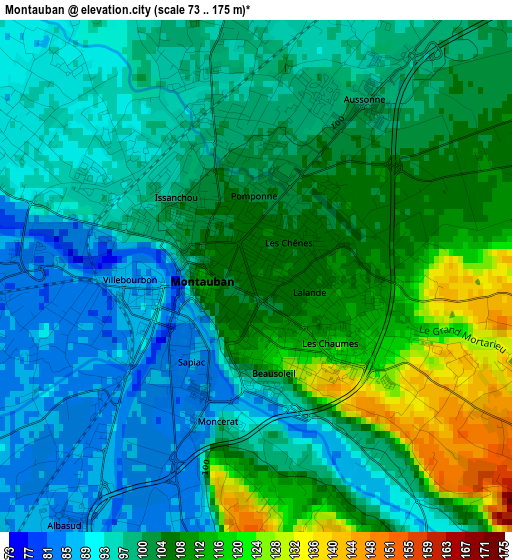
Below is the Elevation map of Montauban, which displays elevation range with different colors. Scale of the first map is from 73 to 175 m (240 to 574 ft) with average elevation of 101.9 meters (=334 ft) [note 1]
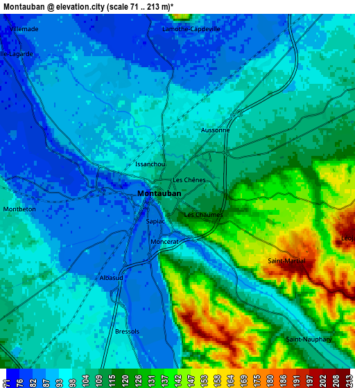
These maps also provides idea of topography and contour of this city, they are displayed at different zoom levels. More info about maps, scale and edge coordinates you can find below images.
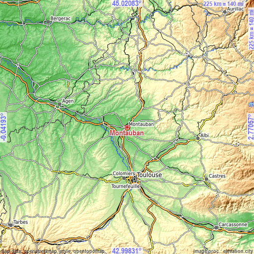
| \ | Map #1 | Map #2 | Topo.Map |
| Scale [m] | 73..175 m | 71..213 m | × |
| Scale [ft] | 240..574 ft | 233..699 ft | × |
| Average | 101.9 m = 334 ft | 105.5 m = 346 ft | × |
| Width | 7.03 km = 4.4 mi | 14.06 km = 8.7 mi | 224.9 km = 139.7 mi |
| Height | 7.03 km = 4.4 mi | 14.06 km = 8.7 mi | 224.9 km = 139.7 mi |
| ↑Max Latitude | 44.049783° | 44.08136° | 45.02083° |
| Latitude at center | 44.01819° | 44.01819° | 44.01819° |
| ↓Min Latitude | 43.98658° | 43.954952° | 42.99831° |
| ← Min Longitude | 1.320375° | 1.276429° | -0.04193° |
| Longitude center | 1.36432° | 1.36432° | 1.36432° |
| →Max Longitude | 1.408265° | 1.452211° | 2.77057° |
Nearby cities:
Cities around Montauban sort by population:
• Montech elevation 110 m
12.5 km,  237°
237°
• Nègrepelisse 104 m
13.9 km,  63°
63°
• Labastide-Saint-Pierre 102 m
11.2 km,  179°
179°
• Bressols 95 m
6 km,  200°
200°
• Saint-Etienne-de-Tulmont 111 m
8.9 km,  66°
66°
• Albias 91 m
10.5 km,  39°
39°
• Montbeton 84 m
5.1 km,  268°
268°
• Réalville 108 m
14.1 km, 40°
• Corbarieu 92 m
8.2 km, 177°
• Saint-Nauphary 103 m
7.5 km,  139°
139°
• Orgueil 109 m
13 km,  163°
163°
• Campsas 134 m
13.9 km,  192°
192°
Multilingual:
 En español:
Montauban elevación 105 m.
 En France:
Montauban élévation 105 m.
 Auf Deutsch:
Montauban höhe über dem Meeresspiegel ist 105 m.

Sources and notes:
- [note 1] Map square and city borders are not equal. Map elevation data is calculated only from area inside that square.
- [src 1] Elevation data from geonames database provided with same terms of usage.
- [src 2] The elevation map of Montauban is generated using elevation data from NASA's 3 arcsec (90m) resolution SRTM data.
- [src 3] Base (background) map © OpenStreetMap contributors tiles are generated by Geofabrik and OpenTopoMap.
Copyright & License:
This Montauban Elevation Map is licensed under CC BY-SA. You may reuse any part from this page, if you give a proper credit by linking to this URL:
 More info on terms of use page.