Morosaglia elevation
Morosaglia (Corsica, Département de la Haute-Corse), France elevation is 908 meters and Morosaglia elevation in feet is 2979 ft above sea level [src 1]. Morosaglia is a populated place (feature code) with elevation that is 734 meters (2408 ft) bigger than average city elevation in France.
Below is the Elevation map of Morosaglia, which displays elevation range with different colors. Scale of the first map is from 257 to 1619 m (843 to 5312 ft) with average elevation of 788.5 meters (=2587 ft) [note 1]
These maps also provides idea of topography and contour of this city, they are displayed at different zoom levels. More info about maps, scale and edge coordinates you can find below images.
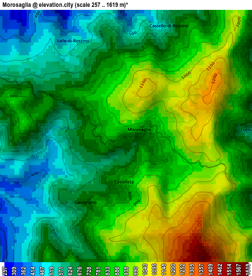
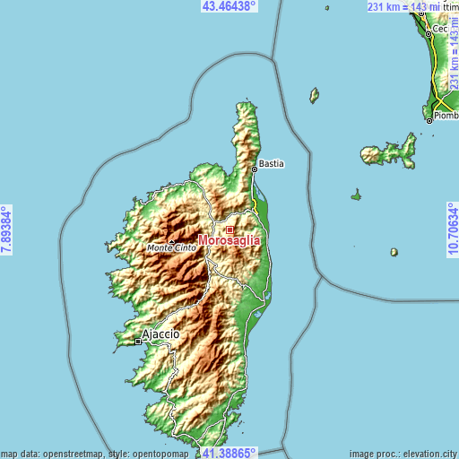
| \ | Map #1 | Topo.Map |
| Scale [m] | 257..1619 m | × |
| Scale [ft] | 843..5312 ft | × |
| Average | 788.5 m = 2587 ft | × |
| Width | 7.21 km = 4.5 mi | 230.8 km = 143.4 mi |
| Height | 7.21 km = 4.5 mi | 230.8 km = 143.4 mi |
| ↑Max Latitude | 42.467535° | 43.46438° |
| Latitude at center | 42.43511° | 42.43511° |
| ↓Min Latitude | 42.402668° | 41.38865° |
| ← Min Longitude | 9.256145° | 7.89384° |
| Longitude center | 9.30009° | 9.30009° |
| →Max Longitude | 9.344035° | 10.70634° |
Nearby cities:
Cities around Morosaglia sort by population:
• Corte elevation 433 m
18.7 km,  221°
221°
• Biguglia 40 m
23.5 km,  24°
24°
• Borgo 266 m
16.9 km,  37°
37°
• Furiani 204 m
26.5 km, 20°
• Lucciana 210 m
15.7 km, 38°
• Penta-di-Casinca 244 m
13.5 km,  75°
75°
• Vescovato 175 m
13.1 km,  60°
60°
• Cervione 138 m
19.8 km,  126°
126°
• San-Nicolao 20 m
19 km,  112°
112°
• Oletta 376 m
22.1 km,  11°
11°
• Santa-Lucia-di-Moriani 11 m
19.2 km, 107°
• Linguizzetta 217 m
23.8 km,  143°
143°
Multilingual:
 En español:
Morosaglia elevación 908 m.
 En France:
Morosaglia élévation 908 m.
 Auf Deutsch:
Morosaglia höhe über dem Meeresspiegel ist 908 m.

Sources and notes:
- [note 1] Map square and city borders are not equal. Map elevation data is calculated only from area inside that square.
- [src 1] Elevation data from geonames database provided with same terms of usage.
- [src 2] The elevation map of Morosaglia is generated using elevation data from NASA's 3 arcsec (90m) resolution SRTM data.
- [src 3] Base (background) map © OpenStreetMap contributors tiles are generated by Geofabrik and OpenTopoMap.
Copyright & License:
This Morosaglia Elevation Map is licensed under CC BY-SA. You may reuse any part from this page, if you give a proper credit by linking to this URL:
 More info on terms of use page.