Mouriès elevation
Mouriès (Provence-Alpes-Côte d'Azur, Département des Bouches-du-Rhône), France elevation is 19 meters and Mouriès elevation in feet is 62 ft above sea level [src 1]. Mouriès is a populated place (feature code) with elevation that is 155 meters (509 ft) smaller than average city elevation in France.
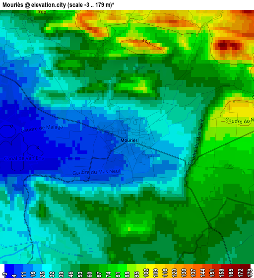
Below is the Elevation map of Mouriès, which displays elevation range with different colors. Scale of the first map is from -3 to 179 m (-10 to 587 ft) with average elevation of 49.4 meters (=162 ft) [note 1]
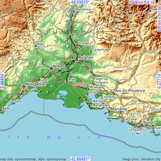
These maps also provides idea of topography and contour of this city, they are displayed at different zoom levels. More info about maps, scale and edge coordinates you can find below images.
| \ | Map #1 | Topo.Map |
| Scale [m] | -3..179 m | × |
| Scale [ft] | -10..587 ft | × |
| Average | 49.4 m = 162 ft | × |
| Width | 7.07 km = 4.4 mi | 226.1 km = 140.5 mi |
| Height | 7.07 km = 4.4 mi | 226.1 km = 140.5 mi |
| ↑Max Latitude | 43.721738° | 44.69819° |
| Latitude at center | 43.68997° | 43.68997° |
| ↓Min Latitude | 43.658185° | 42.66451° |
| ← Min Longitude | 4.826945° | 3.46464° |
| Longitude center | 4.87089° | 4.87089° |
| →Max Longitude | 4.914835° | 6.27714° |
Nearby cities:
Cities around Mouriès sort by population:
• Miramas elevation 50 m
15.8 km,  137°
137°
• Saint-Martin-de-Crau 22 m
7.3 km,  219°
219°
• Saint-Rémy-de-Provence 63 m
11.4 km,  343°
343°
• Eyguières 98 m
12.9 km,  87°
87°
• Eyragues 28 m
17 km,  352°
352°
• Fontvieille 18 m
13.6 km,  288°
288°
• Mollégès 57 m
14.5 km,  25°
25°
• Saint-Étienne-du-Grès 31 m
15.4 km,  310°
310°
• Maussane-les-Alpilles 36 m
6.4 km,  304°
304°
• Eygalières 112 m
10.1 km,  38°
38°
• Aureille 138 m
6.5 km,  71°
71°
• Paradou 21 m
7.5 km, 293°
Multilingual:
 En español:
Mouriès elevación 19 m.
 En France:
Mouriès élévation 19 m.


Sources and notes:
- [note 1] Map square and city borders are not equal. Map elevation data is calculated only from area inside that square.
- [src 1] Elevation data from geonames database provided with same terms of usage.
- [src 2] The elevation map of Mouriès is generated using elevation data from NASA's 3 arcsec (90m) resolution SRTM data.
- [src 3] Base (background) map © OpenStreetMap contributors tiles are generated by Geofabrik and OpenTopoMap.
Copyright & License:
This Mouriès Elevation Map is licensed under CC BY-SA. You may reuse any part from this page, if you give a proper credit by linking to this URL:
 More info on terms of use page.