Moûtiers elevation
Moûtiers (Auvergne-Rhône-Alpes, Savoie), France elevation is 555 meters and Moûtiers elevation in feet is 1821 ft above sea level [src 1]. Moûtiers is a populated place (feature code) with elevation that is 381 meters (1250 ft) bigger than average city elevation in France.
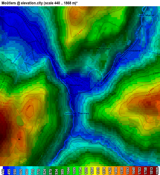
Below is the Elevation map of Moûtiers, which displays elevation range with different colors. Scale of the first map is from 440 to 1868 m (1444 to 6129 ft) with average elevation of 914.9 meters (=3002 ft) [note 1]
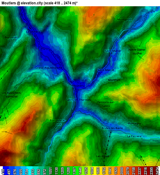
These maps also provides idea of topography and contour of this city, they are displayed at different zoom levels. More info about maps, scale and edge coordinates you can find below images.
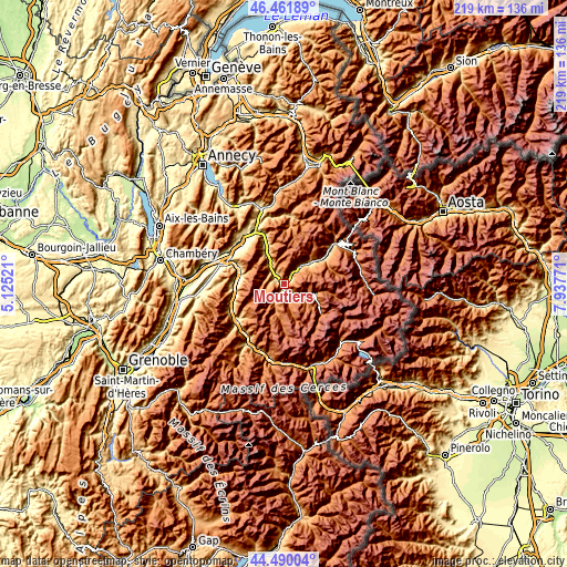
| \ | Map #1 | Map #2 | Topo.Map |
| Scale [m] | 440..1868 m | 418..2474 m | × |
| Scale [ft] | 1444..6129 ft | 1371..8117 ft | × |
| Average | 914.9 m = 3002 ft | 1189.8 m = 3904 ft | × |
| Width | 6.85 km = 4.3 mi | 13.7 km = 8.5 mi | 219.2 km = 136.2 mi |
| Height | 6.85 km = 4.3 mi | 13.7 km = 8.5 mi | 219.2 km = 136.2 mi |
| ↑Max Latitude | 45.515392° | 45.546177° | 46.46189° |
| Latitude at center | 45.48459° | 45.48459° | 45.48459° |
| ↓Min Latitude | 45.453771° | 45.422936° | 44.49004° |
| ← Min Longitude | 6.487515° | 6.443569° | 5.12521° |
| Longitude center | 6.53146° | 6.53146° | 6.53146° |
| →Max Longitude | 6.575405° | 6.619351° | 7.93771° |
Nearby cities:
Cities around Moûtiers sort by population:
• Aime elevation 678 m
12.2 km,  49°
49°
• Saint-Martin-de-Belleville 1390 m
11.6 km,  190°
190°
• Aigueblanche 543 m
3.2 km,  313°
313°
• Méribel 1424 m
8.2 km,  161°
161°
• La Bâthie 457 m
17.2 km,  338°
338°
• Bozel 864 m
10.3 km,  116°
116°
• Les Allues 1115 m
6.1 km, 161°
• Saint-Bon-Tarentaise 1117 m
10 km, 124°
• Courchevel 1756 m
11.2 km,  133°
133°
• Mâcot-la-Plagne 769 m
12.8 km,  55°
55°
• Belle-Plagne 2079 m
13.9 km,  78°
78°
• Salins-les-Thermes 592 m
1.4 km,  182°
182°
Multilingual:
 En español:
Moûtiers elevación 555 m.
 En France:
Moûtiers, Moutiers élévation 555 m.
 Auf Deutsch:
Moûtiers höhe über dem Meeresspiegel ist 555 m.

Sources and notes:
- [note 1] Map square and city borders are not equal. Map elevation data is calculated only from area inside that square.
- [src 1] Elevation data from geonames database provided with same terms of usage.
- [src 2] The elevation map of Moûtiers is generated using elevation data from NASA's 3 arcsec (90m) resolution SRTM data.
- [src 3] Base (background) map © OpenStreetMap contributors tiles are generated by Geofabrik and OpenTopoMap.
Copyright & License:
This Moûtiers Elevation Map is licensed under CC BY-SA. You may reuse any part from this page, if you give a proper credit by linking to this URL:
 More info on terms of use page.