Nay elevation
Nay (Nouvelle-Aquitaine, Département des Pyrénées-Atlantiques), France elevation is 315 meters and Nay elevation in feet is 1033 ft above sea level [src 1]. Nay is a populated place (feature code) with elevation that is 141 meters (463 ft) bigger than average city elevation in France.
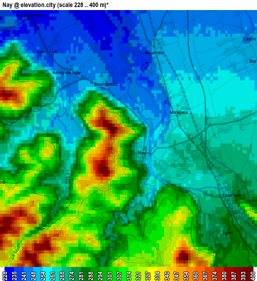
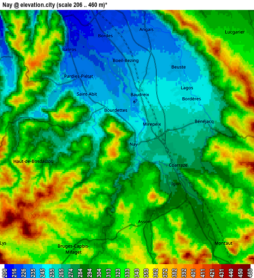
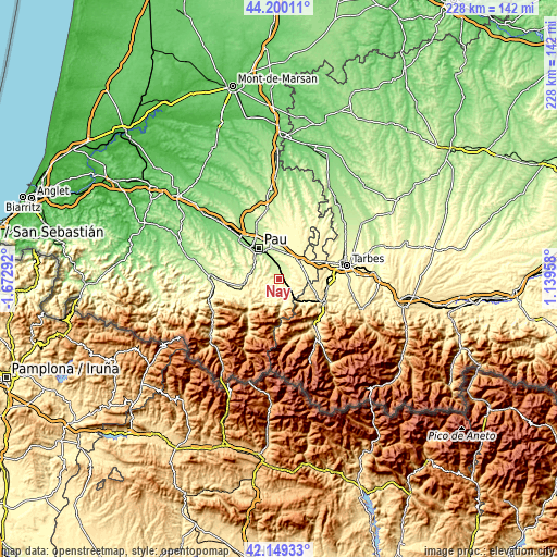
Below is the Elevation map of Nay, which displays elevation range with different colors. Scale of the first map is from 228 to 400 m (748 to 1312 ft) with average elevation of 280.2 meters (=919 ft) [note 1]
These maps also provides idea of topography and contour of this city, they are displayed at different zoom levels. More info about maps, scale and edge coordinates you can find below images.
| \ | Map #1 | Map #2 | Topo.Map |
| Scale [m] | 228..400 m | 206..460 m | × |
| Scale [ft] | 748..1312 ft | 676..1509 ft | × |
| Average | 280.2 m = 919 ft | 303.6 m = 996 ft | × |
| Width | 7.13 km = 4.4 mi | 14.25 km = 8.9 mi | 228 km = 141.7 mi |
| Height | 7.13 km = 4.4 mi | 14.25 km = 8.9 mi | 228 km = 141.7 mi |
| ↑Max Latitude | 43.215365° | 43.247383° | 44.20011° |
| Latitude at center | 43.18333° | 43.18333° | 43.18333° |
| ↓Min Latitude | 43.151278° | 43.119209° | 42.14933° |
| ← Min Longitude | -0.310615° | -0.354561° | -1.67292° |
| Longitude center | -0.26667° | -0.26667° | -0.26667° |
| →Max Longitude | -0.222725° | -0.178779° | 1.13958° |
Nearby cities:
Cities around Nay sort by population:
• Coarraze elevation 271 m
3.3 km,  124°
124°
• Bordes 221 m
5.7 km,  346°
346°
• Asson 338 m
3.9 km,  159°
159°
• Bénéjacq 254 m
4.5 km,  65°
65°
• Assat 213 m
7.9 km,  339°
339°
• Lestelle-Bétharram 296 m
6.9 km,  143°
143°
• Montaut 316 m
7.8 km, 135°
• Mirepeix 262 m
1.4 km,  90°
90°
• Igon 271 m
3.3 km, 124°
• Nousty 266 m
10.1 km,  23°
23°
• Bosdarros 277 m
8.9 km,  294°
294°
• Boeil-Bezing 232 m
3.7 km,  0°
0°
Multilingual:
 En español:
Nay elevación 315 m.
 En France:
Nay élévation 315 m.


Sources and notes:
- [note 1] Map square and city borders are not equal. Map elevation data is calculated only from area inside that square.
- [src 1] Elevation data from geonames database provided with same terms of usage.
- [src 2] The elevation map of Nay is generated using elevation data from NASA's 3 arcsec (90m) resolution SRTM data.
- [src 3] Base (background) map © OpenStreetMap contributors tiles are generated by Geofabrik and OpenTopoMap.
Copyright & License:
This Nay Elevation Map is licensed under CC BY-SA. You may reuse any part from this page, if you give a proper credit by linking to this URL:
 More info on terms of use page.