Nesmy elevation
Nesmy (Pays de la Loire, Département de la Vendée), France elevation is 63 meters and Nesmy elevation in feet is 207 ft above sea level [src 1]. Nesmy is a populated place (feature code) with elevation that is 111 meters (364 ft) smaller than average city elevation in France.
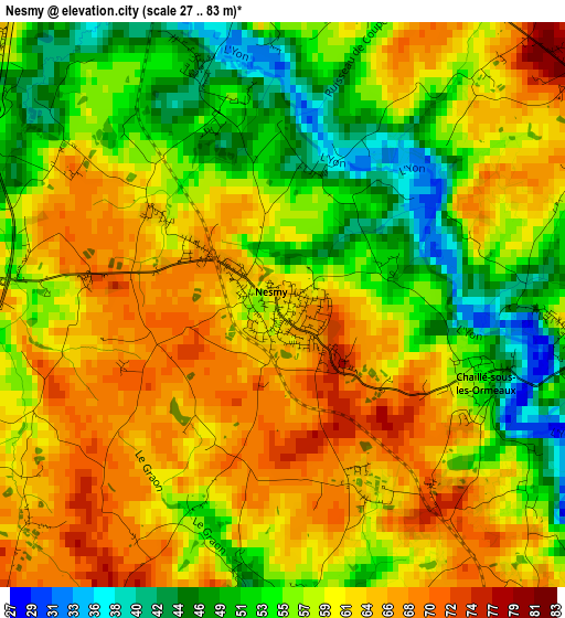
Below is the Elevation map of Nesmy, which displays elevation range with different colors. Scale of the first map is from 27 to 83 m (89 to 272 ft) with average elevation of 58.9 meters (=193 ft) [note 1]
These maps also provides idea of topography and contour of this city, they are displayed at different zoom levels. More info about maps, scale and edge coordinates you can find below images.
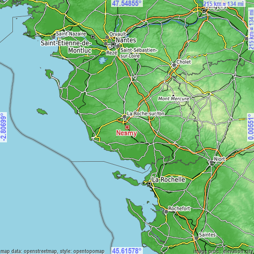
| \ | Map #1 | Topo.Map |
| Scale [m] | 27..83 m | × |
| Scale [ft] | 89..272 ft | × |
| Average | 58.9 m = 193 ft | × |
| Width | 6.72 km = 4.2 mi | 214.9 km = 133.5 mi |
| Height | 6.72 km = 4.2 mi | 214.9 km = 133.5 mi |
| ↑Max Latitude | 46.620971° | 47.54855° |
| Latitude at center | 46.59078° | 46.59078° |
| ↓Min Latitude | 46.560572° | 45.61578° |
| ← Min Longitude | -1.444685° | -2.80699° |
| Longitude center | -1.40074° | -1.40074° |
| →Max Longitude | -1.356795° | 0.00551° |
Nearby cities:
Cities around Nesmy sort by population:
• La Roche-sur-Yon elevation 65 m
8.8 km,  343°
343°
• Venansault 53 m
13.6 km,  320°
320°
• La Chaize-le-Vicomte 82 m
12.3 km,  43°
43°
• Saint-Florent-des-Bois 46 m
6.5 km,  87°
87°
• Aubigny 56 m
4.1 km,  278°
278°
• Les Clouzeaux 60 m
9.3 km,  296°
296°
• Nieul-le-Dolent 70 m
8.4 km,  257°
257°
• Moutiers-les-Mauxfaits 34 m
12 km,  185°
185°
• Le Champ-Saint-Père 31 m
10.1 km,  156°
156°
• Château-Guibert 43 m
12.6 km, 94°
• La Boissière-des-Landes 76 m
5.5 km,  237°
237°
• Saint-Vincent-sur-Graon 38 m
8.3 km,  173°
173°
Multilingual:
 En español:
Nesmy elevación 63 m.
 En France:
Nesmy élévation 63 m.


Sources and notes:
- [note 1] Map square and city borders are not equal. Map elevation data is calculated only from area inside that square.
- [src 1] Elevation data from geonames database provided with same terms of usage.
- [src 2] The elevation map of Nesmy is generated using elevation data from NASA's 3 arcsec (90m) resolution SRTM data.
- [src 3] Base (background) map © OpenStreetMap contributors tiles are generated by Geofabrik and OpenTopoMap.
Copyright & License:
This Nesmy Elevation Map is licensed under CC BY-SA. You may reuse any part from this page, if you give a proper credit by linking to this URL:
 More info on terms of use page.