Niort elevation
Niort (Nouvelle-Aquitaine, Département des Deux-Sèvres), France elevation is 21 meters and Niort elevation in feet is 69 ft above sea level [src 1]. Niort is a seat of a second-order administrative division (feature code) with elevation that is 153 meters (502 ft) smaller than average city elevation in France.
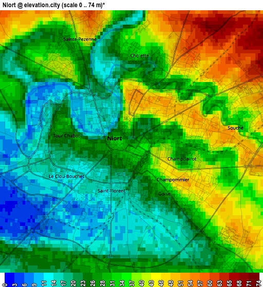
Below is the Elevation map of Niort, which displays elevation range with different colors. Scale of the first map is from 0 to 74 m (0 to 243 ft) with average elevation of 30.1 meters (=99 ft) [note 1]
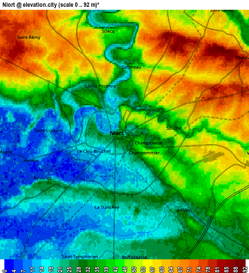
These maps also provides idea of topography and contour of this city, they are displayed at different zoom levels. More info about maps, scale and edge coordinates you can find below images.
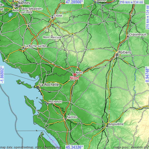
| \ | Map #1 | Map #2 | Topo.Map |
| Scale [m] | 0..74 m | 0..92 m | × |
| Scale [ft] | 0..243 ft | 0..302 ft | × |
| Average | 30.1 m = 99 ft | 37.2 m = 122 ft | × |
| Width | 6.75 km = 4.2 mi | 13.5 km = 8.4 mi | 216 km = 134.2 mi |
| Height | 6.75 km = 4.2 mi | 13.5 km = 8.4 mi | 216 km = 134.2 mi |
| ↑Max Latitude | 46.35347° | 46.383793° | 47.28566° |
| Latitude at center | 46.32313° | 46.32313° | 46.32313° |
| ↓Min Latitude | 46.292773° | 46.2624° | 45.34336° |
| ← Min Longitude | -0.502715° | -0.546661° | -1.86502° |
| Longitude center | -0.45877° | -0.45877° | -0.45877° |
| →Max Longitude | -0.414825° | -0.370879° | 0.94748° |
Nearby cities:
Cities around Niort sort by population:
• Chauray elevation 66 m
7.5 km,  56°
56°
• Aiffres 31 m
5.1 km,  138°
138°
• Échiré 50 m
8.1 km,  23°
23°
• Magné 10 m
6.8 km,  262°
262°
• Vouillé 53 m
7.1 km,  97°
97°
• Frontenay-Rohan-Rohan 22 m
9.9 km,  217°
217°
• Coulon 6 m
9.7 km,  270°
270°
• Saint-Symphorien 16 m
7 km,  201°
201°
• Saint-Gelais 58 m
8.5 km,  38°
38°
• Bessines 5 m
5 km,  242°
242°
• Fors 51 m
10.4 km,  158°
158°
• Saint-Maxire 22 m
8.6 km,  349°
349°
Multilingual:
 En español:
Niort elevación 21 m.
 En France:
Niort élévation 21 m.


Sources and notes:
- [note 1] Map square and city borders are not equal. Map elevation data is calculated only from area inside that square.
- [src 1] Elevation data from geonames database provided with same terms of usage.
- [src 2] The elevation map of Niort is generated using elevation data from NASA's 3 arcsec (90m) resolution SRTM data.
- [src 3] Base (background) map © OpenStreetMap contributors tiles are generated by Geofabrik and OpenTopoMap.
Copyright & License:
This Niort Elevation Map is licensed under CC BY-SA. You may reuse any part from this page, if you give a proper credit by linking to this URL:
 More info on terms of use page.