Noailles elevation
Noailles (Hauts-de-France, Département de l'Oise), France elevation is 93 meters and Noailles elevation in feet is 305 ft above sea level [src 1]. Noailles is a populated place (feature code) with elevation that is 81 meters (266 ft) smaller than average city elevation in France.
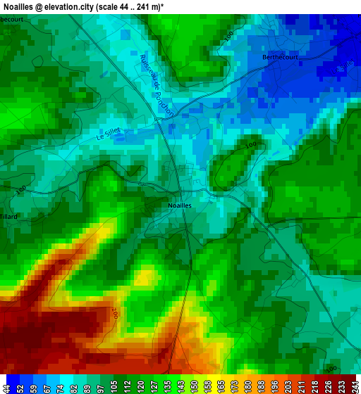
Below is the Elevation map of Noailles, which displays elevation range with different colors. Scale of the first map is from 44 to 241 m (144 to 791 ft) with average elevation of 113.3 meters (=372 ft) [note 1]
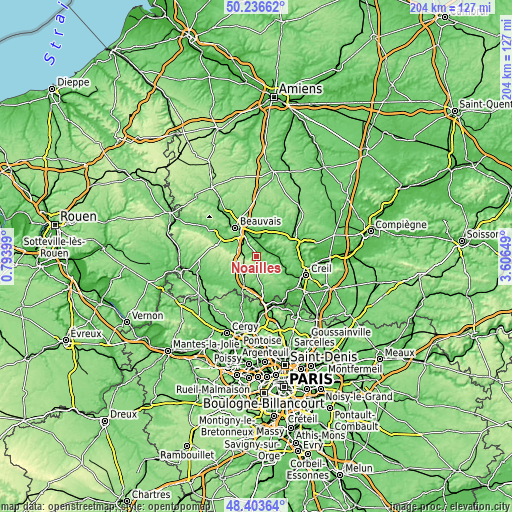
These maps also provides idea of topography and contour of this city, they are displayed at different zoom levels. More info about maps, scale and edge coordinates you can find below images.
| \ | Map #1 | Topo.Map |
| Scale [m] | 44..241 m | × |
| Scale [ft] | 144..791 ft | × |
| Average | 113.3 m = 372 ft | × |
| Width | 6.37 km = 4 mi | 203.8 km = 126.6 mi |
| Height | 6.37 km = 4 mi | 203.8 km = 126.6 mi |
| ↑Max Latitude | 49.357292° | 50.23662° |
| Latitude at center | 49.32866° | 49.32866° |
| ↓Min Latitude | 49.300012° | 48.40364° |
| ← Min Longitude | 2.156295° | 0.79399° |
| Longitude center | 2.20024° | 2.20024° |
| →Max Longitude | 2.244185° | 3.60649° |
Nearby cities:
Cities around Noailles sort by population:
• Mouy elevation 44 m
8.8 km,  99°
99°
• Andeville 158 m
8 km,  199°
199°
• Sainte-Geneviève 203 m
4.4 km,  181°
181°
• Hermes 58 m
4.8 km,  42°
42°
• Bailleul-sur-Thérain 53 m
6.5 km,  14°
14°
• Ully-Saint-Georges 70 m
8 km,  133°
133°
• Berthecourt 59 m
3 km, 35°
• Laboissière-en-Thelle 198 m
4.8 km,  215°
215°
• Cauvigny 82 m
4.6 km, 130°
• Warluis 63 m
7.9 km,  327°
327°
• Saint-Sulpice 103 m
6.1 km,  293°
293°
• Ponchon 91 m
2 km,  352°
352°
Multilingual:
 En español:
Noailles elevación 93 m.
 En France:
Noailles élévation 93 m.


Sources and notes:
- [note 1] Map square and city borders are not equal. Map elevation data is calculated only from area inside that square.
- [src 1] Elevation data from geonames database provided with same terms of usage.
- [src 2] The elevation map of Noailles is generated using elevation data from NASA's 3 arcsec (90m) resolution SRTM data.
- [src 3] Base (background) map © OpenStreetMap contributors tiles are generated by Geofabrik and OpenTopoMap.
Copyright & License:
This Noailles Elevation Map is licensed under CC BY-SA. You may reuse any part from this page, if you give a proper credit by linking to this URL:
 More info on terms of use page.