Nozay elevation
Nozay (Pays de la Loire, Loire-Atlantique), France elevation is 53 meters and Nozay elevation in feet is 174 ft above sea level [src 1]. Nozay is a populated place (feature code) with elevation that is 121 meters (397 ft) smaller than average city elevation in France.
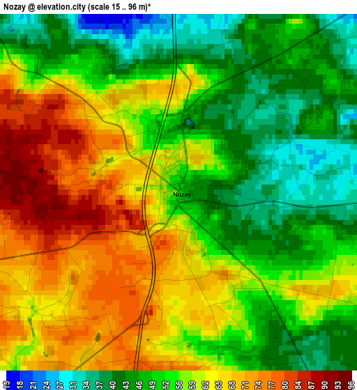
Below is the Elevation map of Nozay, which displays elevation range with different colors. Scale of the first map is from 15 to 96 m (49 to 315 ft) with average elevation of 56.6 meters (=186 ft) [note 1]
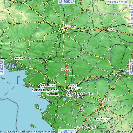
These maps also provides idea of topography and contour of this city, they are displayed at different zoom levels. More info about maps, scale and edge coordinates you can find below images.
| \ | Map #1 | Topo.Map |
| Scale [m] | 15..96 m | × |
| Scale [ft] | 49..315 ft | × |
| Average | 56.6 m = 186 ft | × |
| Width | 6.59 km = 4.1 mi | 211 km = 131.1 mi |
| Height | 6.59 km = 4.1 mi | 211 km = 131.1 mi |
| ↑Max Latitude | 47.594594° | 48.50524° |
| Latitude at center | 47.56495° | 47.56495° |
| ↓Min Latitude | 47.535289° | 46.60748° |
| ← Min Longitude | -1.670235° | -3.03254° |
| Longitude center | -1.62629° | -1.62629° |
| →Max Longitude | -1.582345° | -0.22004° |
Nearby cities:
Cities around Nozay sort by population:
• Blain elevation 27 m
14.2 km,  226°
226°
• Derval 53 m
11.8 km,  343°
343°
• Saffré 27 m
7.9 km,  153°
153°
• Abbaretz 72 m
7.2 km,  100°
100°
• Saint-Vincent-des-Landes 56 m
14.2 km,  43°
43°
• Vay 63 m
5.7 km,  258°
258°
• La Grigonnais 55 m
5.2 km,  216°
216°
• Marsac-sur-Don 43 m
5.3 km,  311°
311°
• Jans 23 m
6.2 km,  8°
8°
• Conquereuil 32 m
11.5 km, 305°
• Le Gâvre 31 m
10.4 km,  242°
242°
• Lusanger 67 m
13.3 km, 12°
Multilingual:
 En español:
Nozay elevación 53 m.
 En France:
Nozay élévation 53 m.


Sources and notes:
- [note 1] Map square and city borders are not equal. Map elevation data is calculated only from area inside that square.
- [src 1] Elevation data from geonames database provided with same terms of usage.
- [src 2] The elevation map of Nozay is generated using elevation data from NASA's 3 arcsec (90m) resolution SRTM data.
- [src 3] Base (background) map © OpenStreetMap contributors tiles are generated by Geofabrik and OpenTopoMap.
Copyright & License:
This Nozay Elevation Map is licensed under CC BY-SA. You may reuse any part from this page, if you give a proper credit by linking to this URL:
 More info on terms of use page.