Pacy-sur-Eure elevation
Pacy-sur-Eure (Normandy, Département de l'Eure), France elevation is 51 meters and Pacy-sur-Eure elevation in feet is 167 ft above sea level [src 1]. Pacy-sur-Eure is a populated place (feature code) with elevation that is 123 meters (404 ft) smaller than average city elevation in France.
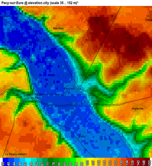
Below is the Elevation map of Pacy-sur-Eure, which displays elevation range with different colors. Scale of the first map is from 35 to 152 m (115 to 499 ft) with average elevation of 89.3 meters (=293 ft) [note 1]
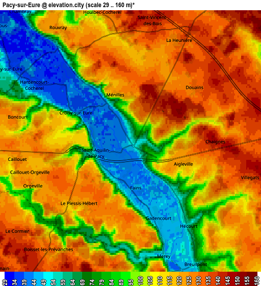
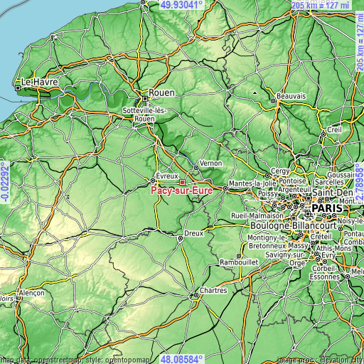
These maps also provides idea of topography and contour of this city, they are displayed at different zoom levels. More info about maps, scale and edge coordinates you can find below images.
| \ | Map #1 | Map #2 | Topo.Map |
| Scale [m] | 35..152 m | 29..160 m | × |
| Scale [ft] | 115..499 ft | 95..525 ft | × |
| Average | 89.3 m = 293 ft | 105.4 m = 346 ft | × |
| Width | 6.41 km = 4 mi | 12.82 km = 8 mi | 205.1 km = 127.4 mi |
| Height | 6.41 km = 4 mi | 12.82 km = 8 mi | 205.1 km = 127.4 mi |
| ↑Max Latitude | 49.045483° | 49.074279° | 49.93041° |
| Latitude at center | 49.01667° | 49.01667° | 49.01667° |
| ↓Min Latitude | 48.987841° | 48.958994° | 48.08584° |
| ← Min Longitude | 1.339385° | 1.295439° | -0.02292° |
| Longitude center | 1.38333° | 1.38333° | 1.38333° |
| →Max Longitude | 1.427275° | 1.471221° | 2.78958° |
Nearby cities:
Cities around Pacy-sur-Eure sort by population:
• Vernon elevation 29 m
10.3 km,  34°
34°
• Saint-Marcel 28 m
10.5 km, 27°
• Bennecourt 38 m
12.8 km,  77°
77°
• Limetz-Villez 16 m
13.4 km,  65°
65°
• Garennes-sur-Eure 58 m
12.4 km,  161°
161°
• Bréval 127 m
13.5 km,  125°
125°
• Bueil 74 m
10.4 km, 155°
• Ménilles 42 m
2.2 km,  326°
326°
• Saint-Just 26 m
11 km,  22°
22°
• Houlbec-Cocherel 134 m
6.4 km,  348°
348°
• Breuilpont 75 m
6.7 km,  150°
150°
• La Chapelle-Réanville 125 m
9 km,  359°
359°
Multilingual:
 En español:
Pacy-sur-Eure elevación 51 m.
 En France:
Pacy-sur-Eure élévation 51 m.
 Auf Deutsch:
Pacy-sur-Eure höhe über dem Meeresspiegel ist 51 m.

Sources and notes:
- [note 1] Map square and city borders are not equal. Map elevation data is calculated only from area inside that square.
- [src 1] Elevation data from geonames database provided with same terms of usage.
- [src 2] The elevation map of Pacy-sur-Eure is generated using elevation data from NASA's 3 arcsec (90m) resolution SRTM data.
- [src 3] Base (background) map © OpenStreetMap contributors tiles are generated by Geofabrik and OpenTopoMap.
Copyright & License:
This Pacy-sur-Eure Elevation Map is licensed under CC BY-SA. You may reuse any part from this page, if you give a proper credit by linking to this URL:
 More info on terms of use page.