Parthenay elevation
Parthenay (Nouvelle-Aquitaine, Département des Deux-Sèvres), France elevation is 168 meters and Parthenay elevation in feet is 551 ft above sea level [src 1]. Parthenay is a seat of a third-order administrative division (feature code) with elevation that is 6 meters (20 ft) smaller than average city elevation in France.
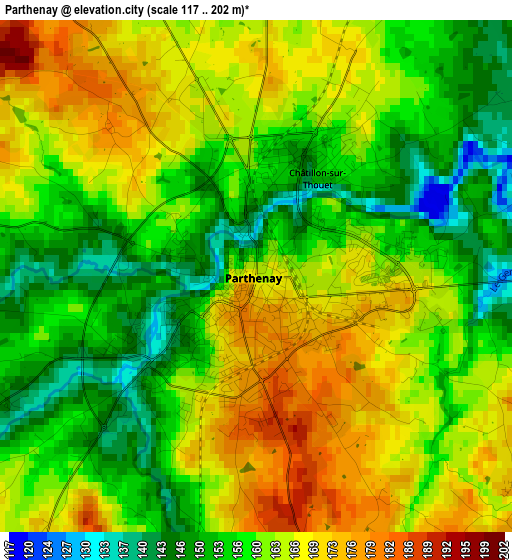
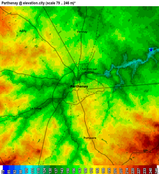
Below is the Elevation map of Parthenay, which displays elevation range with different colors. Scale of the first map is from 117 to 202 m (384 to 663 ft) with average elevation of 160.8 meters (=528 ft) [note 1]
These maps also provides idea of topography and contour of this city, they are displayed at different zoom levels. More info about maps, scale and edge coordinates you can find below images.
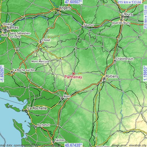
| \ | Map #1 | Map #2 | Topo.Map |
| Scale [m] | 117..202 m | 79..246 m | × |
| Scale [ft] | 384..663 ft | 259..807 ft | × |
| Average | 160.8 m = 528 ft | 168.1 m = 552 ft | × |
| Width | 6.71 km = 4.2 mi | 13.42 km = 8.3 mi | 214.7 km = 133.4 mi |
| Height | 6.71 km = 4.2 mi | 13.42 km = 8.3 mi | 214.7 km = 133.4 mi |
| ↑Max Latitude | 46.678479° | 46.708621° | 47.60507° |
| Latitude at center | 46.64832° | 46.64832° | 46.64832° |
| ↓Min Latitude | 46.618144° | 46.587952° | 45.67435° |
| ← Min Longitude | -0.290665° | -0.334611° | -1.65297° |
| Longitude center | -0.24672° | -0.24672° | -0.24672° |
| →Max Longitude | -0.202775° | -0.158829° | 1.15953° |
Nearby cities:
Cities around Parthenay sort by population:
• Châtillon-sur-Thouet elevation 157 m
1.7 km,  21°
21°
• Saint-Aubin-le-Cloud 178 m
8.2 km,  272°
272°
• Le Tallud 150 m
4.4 km,  243°
243°
• Pompaire 190 m
4.6 km,  167°
167°
• Secondigny 187 m
13.7 km,  251°
251°
• Vasles 160 m
18.7 km,  115°
115°
• Thénezay 137 m
18.5 km,  64°
64°
• Chiché 153 m
18.7 km,  332°
332°
• Saint-Pardoux 205 m
9.7 km,  207°
207°
• La Peyratte 151 m
8 km,  68°
68°
• Boismé 151 m
20.1 km,  314°
314°
• Viennay 156 m
4.7 km,  2°
2°
Multilingual:
 En español:
Parthenay elevación 168 m.
 En France:
Parthenay élévation 168 m.
 Auf Deutsch:
Parthenay höhe über dem Meeresspiegel ist 168 m.

Sources and notes:
- [note 1] Map square and city borders are not equal. Map elevation data is calculated only from area inside that square.
- [src 1] Elevation data from geonames database provided with same terms of usage.
- [src 2] The elevation map of Parthenay is generated using elevation data from NASA's 3 arcsec (90m) resolution SRTM data.
- [src 3] Base (background) map © OpenStreetMap contributors tiles are generated by Geofabrik and OpenTopoMap.
Copyright & License:
This Parthenay Elevation Map is licensed under CC BY-SA. You may reuse any part from this page, if you give a proper credit by linking to this URL:
 More info on terms of use page.