Peyrilhac elevation
Peyrilhac (Nouvelle-Aquitaine, Haute-Vienne), France elevation is 296 meters and Peyrilhac elevation in feet is 971 ft above sea level [src 1]. Peyrilhac is a populated place (feature code) with elevation that is 122 meters (400 ft) bigger than average city elevation in France.
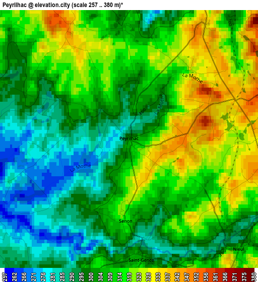
Below is the Elevation map of Peyrilhac, which displays elevation range with different colors. Scale of the first map is from 257 to 380 m (843 to 1247 ft) with average elevation of 307.2 meters (=1008 ft) [note 1]
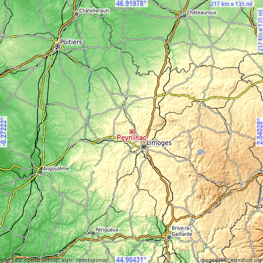
These maps also provides idea of topography and contour of this city, they are displayed at different zoom levels. More info about maps, scale and edge coordinates you can find below images.
| \ | Map #1 | Topo.Map |
| Scale [m] | 257..380 m | × |
| Scale [ft] | 843..1247 ft | × |
| Average | 307.2 m = 1008 ft | × |
| Width | 6.79 km = 4.2 mi | 217.4 km = 135.1 mi |
| Height | 6.79 km = 4.2 mi | 217.4 km = 135.1 mi |
| ↑Max Latitude | 45.981216° | 46.91978° |
| Latitude at center | 45.95067° | 45.95067° |
| ↓Min Latitude | 45.920107° | 44.96431° |
| ← Min Longitude | 1.090085° | -0.27222° |
| Longitude center | 1.13403° | 1.13403° |
| →Max Longitude | 1.177975° | 2.54028° |
Nearby cities:
Cities around Peyrilhac sort by population:
• Couzeix elevation 366 m
11.5 km,  135°
135°
• Verneuil-sur-Vienne 312 m
11.4 km,  182°
182°
• Oradour-sur-Glane 259 m
8.2 km,  256°
256°
• Veyrac 310 m
6.4 km,  200°
200°
• Nantiat 339 m
7.2 km,  24°
24°
• Saint-Victurnien 194 m
12.4 km,  229°
229°
• Saint-Gence 309 m
3.2 km,  174°
174°
• Chaptelat 348 m
10.6 km,  115°
115°
• Compreignac 401 m
11.8 km,  66°
66°
• Saint-Jouvent 340 m
5.5 km,  82°
82°
• Nieul 305 m
4.1 km,  130°
130°
• Bonnac-la-Côte 422 m
11.7 km,  95°
95°
Multilingual:
 En español:
Peyrilhac elevación 296 m.
 En France:
Peyrilhac élévation 296 m.
 Auf Deutsch:
Peyrilhac höhe über dem Meeresspiegel ist 296 m.

Sources and notes:
- [note 1] Map square and city borders are not equal. Map elevation data is calculated only from area inside that square.
- [src 1] Elevation data from geonames database provided with same terms of usage.
- [src 2] The elevation map of Peyrilhac is generated using elevation data from NASA's 3 arcsec (90m) resolution SRTM data.
- [src 3] Base (background) map © OpenStreetMap contributors tiles are generated by Geofabrik and OpenTopoMap.
Copyright & License:
This Peyrilhac Elevation Map is licensed under CC BY-SA. You may reuse any part from this page, if you give a proper credit by linking to this URL:
 More info on terms of use page.