Piolenc elevation
Piolenc (Provence-Alpes-Côte d'Azur, Département du Vaucluse), France elevation is 41 meters and Piolenc elevation in feet is 135 ft above sea level [src 1]. Piolenc is a populated place (feature code) with elevation that is 133 meters (436 ft) smaller than average city elevation in France.
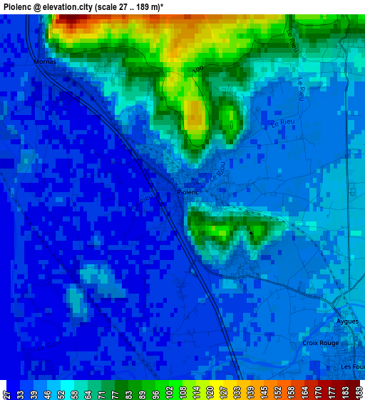
Below is the Elevation map of Piolenc, which displays elevation range with different colors. Scale of the first map is from 27 to 189 m (89 to 620 ft) with average elevation of 50.7 meters (=166 ft) [note 1]
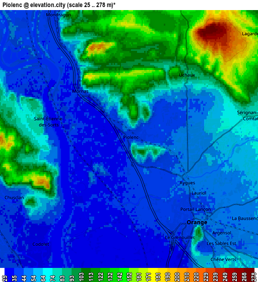
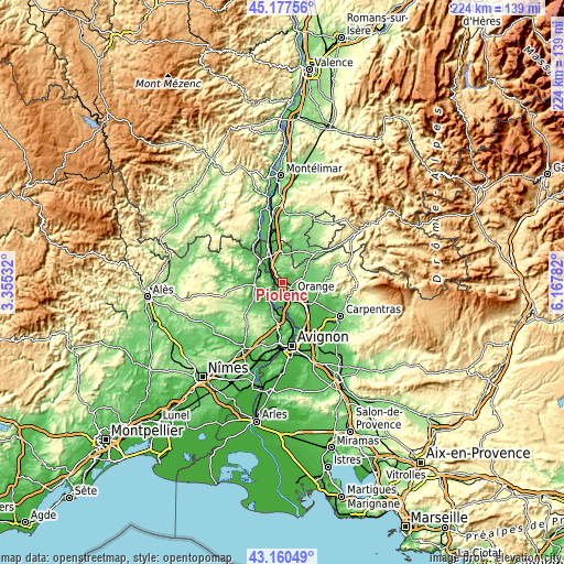
These maps also provides idea of topography and contour of this city, they are displayed at different zoom levels. More info about maps, scale and edge coordinates you can find below images.
| \ | Map #1 | Map #2 | Topo.Map |
| Scale [m] | 27..189 m | 25..278 m | × |
| Scale [ft] | 89..620 ft | 82..912 ft | × |
| Average | 50.7 m = 166 ft | 69.1 m = 227 ft | × |
| Width | 7.01 km = 4.4 mi | 14.02 km = 8.7 mi | 224.3 km = 139.4 mi |
| Height | 7.01 km = 4.4 mi | 14.02 km = 8.7 mi | 224.3 km = 139.4 mi |
| ↑Max Latitude | 44.209158° | 44.24065° | 45.17756° |
| Latitude at center | 44.17765° | 44.17765° | 44.17765° |
| ↓Min Latitude | 44.146125° | 44.114583° | 43.16049° |
| ← Min Longitude | 4.717625° | 4.673679° | 3.35532° |
| Longitude center | 4.76157° | 4.76157° | 4.76157° |
| →Max Longitude | 4.805515° | 4.849461° | 6.16782° |
Nearby cities:
Cities around Piolenc sort by population:
• Orange elevation 43 m
5.9 km,  138°
138°
• Laudun-l'Ardoise 47 m
11.5 km,  221°
221°
• Camaret-sur-Aigues 74 m
9 km,  99°
99°
• Mondragon 101 m
7.8 km,  330°
330°
• Caderousse 32 m
8.3 km,  182°
182°
• Sérignan-du-Comtat 77 m
6.7 km,  78°
78°
• Mornas 110 m
3.9 km,  315°
315°
• Uchaux 118 m
5.3 km,  35°
35°
• Rochegude 120 m
9.1 km, 35°
• Saint-Nazaire 101 m
11.2 km,  281°
281°
• Vénéjan 79 m
8.8 km, 284°
• Orsan 53 m
9.3 km,  236°
236°
Multilingual:
 En español:
Piolenc elevación 41 m.
 En France:
Piolenc élévation 41 m.


Sources and notes:
- [note 1] Map square and city borders are not equal. Map elevation data is calculated only from area inside that square.
- [src 1] Elevation data from geonames database provided with same terms of usage.
- [src 2] The elevation map of Piolenc is generated using elevation data from NASA's 3 arcsec (90m) resolution SRTM data.
- [src 3] Base (background) map © OpenStreetMap contributors tiles are generated by Geofabrik and OpenTopoMap.
Copyright & License:
This Piolenc Elevation Map is licensed under CC BY-SA. You may reuse any part from this page, if you give a proper credit by linking to this URL:
 More info on terms of use page.