Ploemeur elevation
Ploemeur (Brittany, Morbihan), France elevation is 36 meters and Ploemeur elevation in feet is 118 ft above sea level [src 1]. Ploemeur is a populated place (feature code) with elevation that is 138 meters (453 ft) smaller than average city elevation in France.
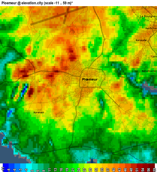
Below is the Elevation map of Ploemeur, which displays elevation range with different colors. Scale of the first map is from -11 to 59 m (-36 to 194 ft) with average elevation of 25.8 meters (=85 ft) [note 1]
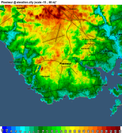
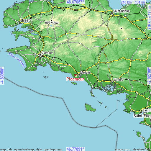
These maps also provides idea of topography and contour of this city, they are displayed at different zoom levels. More info about maps, scale and edge coordinates you can find below images.
| \ | Map #1 | Map #2 | Topo.Map |
| Scale [m] | -11..59 m | -15..68 m | × |
| Scale [ft] | -36..194 ft | -49..223 ft | × |
| Average | 25.8 m = 85 ft | 25.1 m = 82 ft | × |
| Width | 6.57 km = 4.1 mi | 13.15 km = 8.2 mi | 210.3 km = 130.7 mi |
| Height | 6.57 km = 4.1 mi | 13.15 km = 8.2 mi | 210.3 km = 130.7 mi |
| ↑Max Latitude | 47.762878° | 47.79241° | 48.67057° |
| Latitude at center | 47.73333° | 47.73333° | 47.73333° |
| ↓Min Latitude | 47.703765° | 47.674183° | 46.77891° |
| ← Min Longitude | -3.477275° | -3.521221° | -4.83958° |
| Longitude center | -3.43333° | -3.43333° | -3.43333° |
| →Max Longitude | -3.389385° | -3.345439° | -2.02708° |
Nearby cities:
Cities around Ploemeur sort by population:
• Lorient elevation 5 m
5.2 km,  74°
74°
• Lanester 25 m
7.7 km, 66°
• Guidel-Plage 17 m
7.6 km,  300°
300°
• Quéven 51 m
5.7 km,  12°
12°
• Larmor-Plage 12 m
4.8 km,  128°
128°
• Caudan 47 m
10.8 km,  38°
38°
• Riantec 5 m
9.1 km,  105°
105°
• Locmiquélic 12 m
6.9 km,  97°
97°
• Port-Louis 13 m
6.6 km,  116°
116°
• Pont-Scorff 45 m
11.4 km, 11°
• Groix 39 m
10.6 km,  188°
188°
• Gestel 48 m
7.8 km,  355°
355°
Multilingual:
 En español:
Ploemeur elevación 36 m.
 En France:
Ploemeur élévation 36 m.


Sources and notes:
- [note 1] Map square and city borders are not equal. Map elevation data is calculated only from area inside that square.
- [src 1] Elevation data from geonames database provided with same terms of usage.
- [src 2] The elevation map of Ploemeur is generated using elevation data from NASA's 3 arcsec (90m) resolution SRTM data.
- [src 3] Base (background) map © OpenStreetMap contributors tiles are generated by Geofabrik and OpenTopoMap.
Copyright & License:
This Ploemeur Elevation Map is licensed under CC BY-SA. You may reuse any part from this page, if you give a proper credit by linking to this URL:
 More info on terms of use page.