Ploumagoar elevation
Ploumagoar (Brittany, Département des Côtes-d’Armor), France elevation is 114 meters and Ploumagoar elevation in feet is 374 ft above sea level [src 1]. Ploumagoar is a populated place (feature code) with elevation that is 60 meters (197 ft) smaller than average city elevation in France.
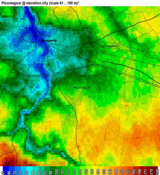
Below is the Elevation map of Ploumagoar, which displays elevation range with different colors. Scale of the first map is from 61 to 180 m (200 to 591 ft) with average elevation of 114.7 meters (=376 ft) [note 1]
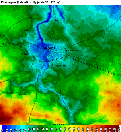
These maps also provides idea of topography and contour of this city, they are displayed at different zoom levels. More info about maps, scale and edge coordinates you can find below images.
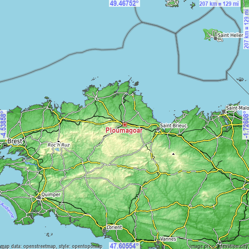
| \ | Map #1 | Map #2 | Topo.Map |
| Scale [m] | 61..180 m | 57..273 m | × |
| Scale [ft] | 200..591 ft | 187..896 ft | × |
| Average | 114.7 m = 376 ft | 137.9 m = 452 ft | × |
| Width | 6.47 km = 4 mi | 12.94 km = 8 mi | 207 km = 128.6 mi |
| Height | 6.47 km = 4 mi | 12.94 km = 8 mi | 207 km = 128.6 mi |
| ↑Max Latitude | 48.574175° | 48.603243° | 49.46752° |
| Latitude at center | 48.54509° | 48.54509° | 48.54509° |
| ↓Min Latitude | 48.515989° | 48.48687° | 47.60554° |
| ← Min Longitude | -3.176275° | -3.220221° | -4.53858° |
| Longitude center | -3.13233° | -3.13233° | -3.13233° |
| →Max Longitude | -3.088385° | -3.044439° | -1.72608° |
Nearby cities:
Cities around Ploumagoar sort by population:
• Guingamp elevation 84 m
2.4 km,  324°
324°
• Pabu 112 m
4.6 km,  356°
356°
• Plélo 116 m
13.7 km,  85°
85°
• Grâces 125 m
4.1 km,  288°
288°
• Bourbriac 209 m
8.9 km,  207°
207°
• Plouagat 141 m
9.8 km,  95°
95°
• Plouisy 133 m
5.3 km,  313°
313°
• Saint-Agathon 117 m
2.5 km,  52°
52°
• Pommerit-le-Vicomte 103 m
8.9 km,  20°
20°
• Pédernec 128 m
11.6 km,  299°
299°
• Goudelin 93 m
10.6 km, 52°
• Lanrodec 198 m
8.1 km,  113°
113°
Multilingual:
 En español:
Ploumagoar elevación 114 m.
 En France:
Ploumagoar élévation 114 m.
 Auf Deutsch:
Ploumagoar höhe über dem Meeresspiegel ist 114 m.

Sources and notes:
- [note 1] Map square and city borders are not equal. Map elevation data is calculated only from area inside that square.
- [src 1] Elevation data from geonames database provided with same terms of usage.
- [src 2] The elevation map of Ploumagoar is generated using elevation data from NASA's 3 arcsec (90m) resolution SRTM data.
- [src 3] Base (background) map © OpenStreetMap contributors tiles are generated by Geofabrik and OpenTopoMap.
Copyright & License:
This Ploumagoar Elevation Map is licensed under CC BY-SA. You may reuse any part from this page, if you give a proper credit by linking to this URL:
 More info on terms of use page.