Plounéour-Ménez elevation
Plounéour-Ménez (Brittany, Département du Finistère), France elevation is 237 meters and Plounéour-Ménez elevation in feet is 778 ft above sea level [src 1]. Plounéour-Ménez is a populated place (feature code) with elevation that is 63 meters (207 ft) bigger than average city elevation in France.
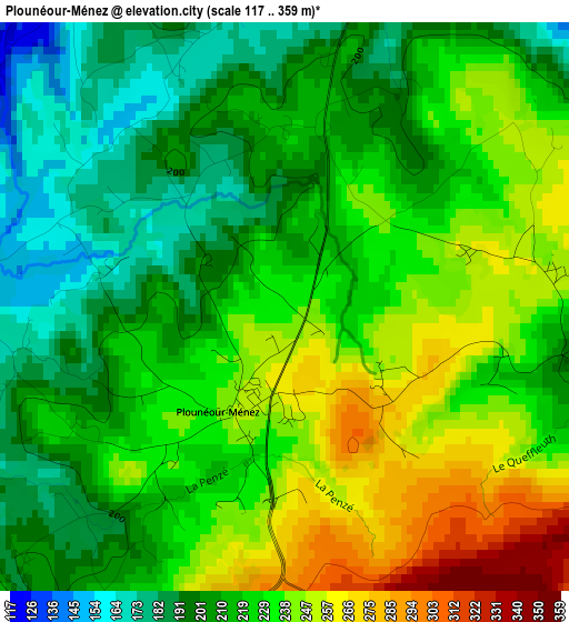
Below is the Elevation map of Plounéour-Ménez, which displays elevation range with different colors. Scale of the first map is from 117 to 359 m (384 to 1178 ft) with average elevation of 222.4 meters (=730 ft) [note 1]
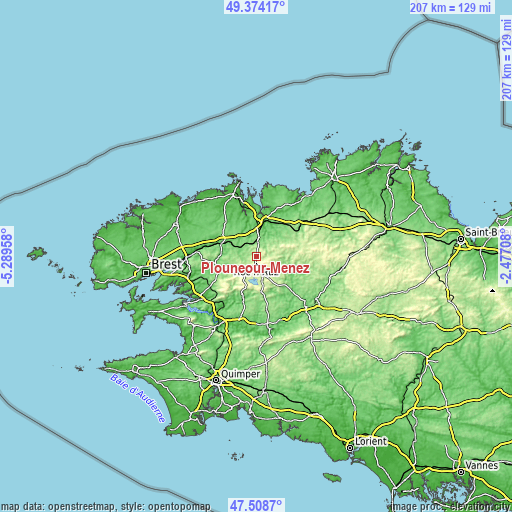
These maps also provides idea of topography and contour of this city, they are displayed at different zoom levels. More info about maps, scale and edge coordinates you can find below images.
| \ | Map #1 | Topo.Map |
| Scale [m] | 117..359 m | × |
| Scale [ft] | 384..1178 ft | × |
| Average | 222.4 m = 730 ft | × |
| Width | 6.48 km = 4 mi | 207.4 km = 128.9 mi |
| Height | 6.48 km = 4 mi | 207.4 km = 128.9 mi |
| ↑Max Latitude | 48.479139° | 49.37417° |
| Latitude at center | 48.45° | 48.45° |
| ↓Min Latitude | 48.420844° | 47.5087° |
| ← Min Longitude | -3.927275° | -5.28958° |
| Longitude center | -3.88333° | -3.88333° |
| →Max Longitude | -3.839385° | -2.47708° |
Nearby cities:
Cities around Plounéour-Ménez sort by population:
• Morlaix elevation 65 m
14.7 km,  16°
16°
• Landivisiau 87 m
15.1 km,  295°
295°
• Saint-Martin-des-Champs 11 m
15.3 km,  13°
13°
• Plourin-lès-Morlaix 131 m
11.8 km,  38°
38°
• Plougonven 144 m
14.3 km,  58°
58°
• Pleyber-Christ 120 m
5.7 km, 12°
• Saint-Thégonnec 89 m
8.9 km,  326°
326°
• Guiclan 107 m
12.5 km, 332°
• Lampaul-Guimiliau 107 m
12.5 km,  291°
291°
• Sizun 103 m
15.8 km,  249°
249°
• Huelgoat 194 m
14.2 km,  134°
134°
• Berrien 261 m
11 km,  118°
118°
Multilingual:
 En español:
Plounéour-Ménez elevación 237 m.
 En France:
Plounéour-Ménez élévation 237 m.
 Auf Deutsch:
Plounéour-Ménez höhe über dem Meeresspiegel ist 237 m.

Sources and notes:
- [note 1] Map square and city borders are not equal. Map elevation data is calculated only from area inside that square.
- [src 1] Elevation data from geonames database provided with same terms of usage.
- [src 2] The elevation map of Plounéour-Ménez is generated using elevation data from NASA's 3 arcsec (90m) resolution SRTM data.
- [src 3] Base (background) map © OpenStreetMap contributors tiles are generated by Geofabrik and OpenTopoMap.
Copyright & License:
This Plounéour-Ménez Elevation Map is licensed under CC BY-SA. You may reuse any part from this page, if you give a proper credit by linking to this URL:
 More info on terms of use page.