Plouvorn elevation
Plouvorn (Brittany, Département du Finistère), France elevation is 73 meters and Plouvorn elevation in feet is 240 ft above sea level [src 1]. Plouvorn is a populated place (feature code) with elevation that is 101 meters (331 ft) smaller than average city elevation in France.
Below is the Elevation map of Plouvorn, which displays elevation range with different colors. Scale of the first map is from 31 to 117 m (102 to 384 ft) with average elevation of 80.6 meters (=264 ft) [note 1]
These maps also provides idea of topography and contour of this city, they are displayed at different zoom levels. More info about maps, scale and edge coordinates you can find below images.
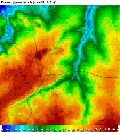
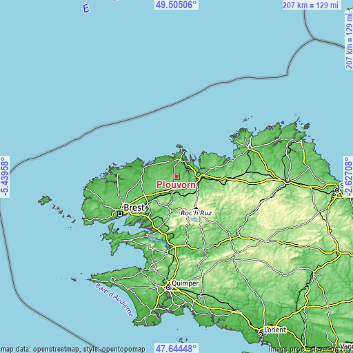
| \ | Map #1 | Topo.Map |
| Scale [m] | 31..117 m | × |
| Scale [ft] | 102..384 ft | × |
| Average | 80.6 m = 264 ft | × |
| Width | 6.46 km = 4 mi | 206.9 km = 128.6 mi |
| Height | 6.46 km = 4 mi | 206.9 km = 128.6 mi |
| ↑Max Latitude | 48.612393° | 49.50506° |
| Latitude at center | 48.58333° | 48.58333° |
| ↓Min Latitude | 48.55425° | 47.64448° |
| ← Min Longitude | -4.077275° | -5.43958° |
| Longitude center | -4.03333° | -4.03333° |
| →Max Longitude | -3.989385° | -2.62708° |
Nearby cities:
Cities around Plouvorn sort by population:
• Landivisiau elevation 87 m
8.8 km,  197°
197°
• Taulé 82 m
10 km,  79°
79°
• Plouénan 60 m
6.1 km,  23°
23°
• Saint-Thégonnec 89 m
9.6 km,  140°
140°
• Guiclan 107 m
6.4 km,  125°
125°
• Lampaul-Guimiliau 107 m
10.2 km,  183°
183°
• Plougoulm 41 m
9.3 km,  352°
352°
• Bodilis 113 m
8.5 km,  225°
225°
• Plouzévédé 90 m
6.4 km,  286°
286°
• Henvic 71 m
9.6 km,  55°
55°
• Sibiril 50 m
9.6 km, 345°
• Plougourvest 112 m
5.2 km,  224°
224°
Multilingual:
 En español:
Plouvorn elevación 73 m.
 En France:
Plouvorn élévation 73 m.


Sources and notes:
- [note 1] Map square and city borders are not equal. Map elevation data is calculated only from area inside that square.
- [src 1] Elevation data from geonames database provided with same terms of usage.
- [src 2] The elevation map of Plouvorn is generated using elevation data from NASA's 3 arcsec (90m) resolution SRTM data.
- [src 3] Base (background) map © OpenStreetMap contributors tiles are generated by Geofabrik and OpenTopoMap.
Copyright & License:
This Plouvorn Elevation Map is licensed under CC BY-SA. You may reuse any part from this page, if you give a proper credit by linking to this URL:
 More info on terms of use page.