Pompignan elevation
Pompignan (Occitanie, Département du Tarn-et-Garonne), France elevation is 121 meters and Pompignan elevation in feet is 397 ft above sea level [src 1]. Pompignan is a populated place (feature code) with elevation that is 53 meters (174 ft) smaller than average city elevation in France.
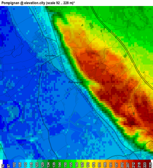
Below is the Elevation map of Pompignan, which displays elevation range with different colors. Scale of the first map is from 92 to 228 m (302 to 748 ft) with average elevation of 135.8 meters (=446 ft) [note 1]
These maps also provides idea of topography and contour of this city, they are displayed at different zoom levels. More info about maps, scale and edge coordinates you can find below images.
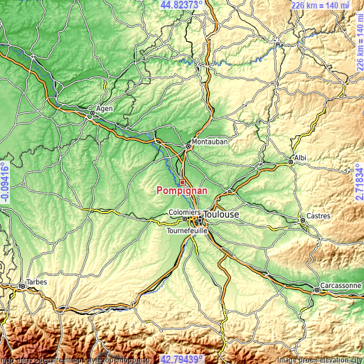
| \ | Map #1 | Topo.Map |
| Scale [m] | 92..228 m | × |
| Scale [ft] | 302..748 ft | × |
| Average | 135.8 m = 446 ft | × |
| Width | 7.05 km = 4.4 mi | 225.6 km = 140.2 mi |
| Height | 7.05 km = 4.4 mi | 225.6 km = 140.2 mi |
| ↑Max Latitude | 43.84938° | 44.82373° |
| Latitude at center | 43.81768° | 43.81768° |
| ↓Min Latitude | 43.785963° | 42.79439° |
| ← Min Longitude | 1.268145° | -0.09416° |
| Longitude center | 1.31209° | 1.31209° |
| →Max Longitude | 1.356035° | 2.71834° |
Nearby cities:
Cities around Pompignan sort by population:
• Grenade elevation 107 m
6.1 km,  202°
202°
• Saint-Jory 120 m
9.7 km,  150°
150°
• Fronton 152 m
6.6 km,  68°
68°
• Bouloc 204 m
8.5 km,  118°
118°
• Verdun-sur-Garonne 103 m
7.5 km,  303°
303°
• Castelnau-d'Estrétefonds 124 m
5.3 km,  135°
135°
• Grisolles 110 m
1.8 km,  316°
316°
• Saint-Sauveur 145 m
10.5 km, 137°
• Villaudric 145 m
9.7 km,  81°
81°
• Villeneuve-lès-Bouloc 157 m
10.5 km, 122°
• Campsas 134 m
8.8 km,  7°
7°
• Ondes 110 m
3.9 km,  184°
184°
Multilingual:
 En español:
Pompignan elevación 121 m.
 En France:
Pompignan élévation 121 m.
 Auf Deutsch:
Pompignan höhe über dem Meeresspiegel ist 121 m.

Sources and notes:
- [note 1] Map square and city borders are not equal. Map elevation data is calculated only from area inside that square.
- [src 1] Elevation data from geonames database provided with same terms of usage.
- [src 2] The elevation map of Pompignan is generated using elevation data from NASA's 3 arcsec (90m) resolution SRTM data.
- [src 3] Base (background) map © OpenStreetMap contributors tiles are generated by Geofabrik and OpenTopoMap.
Copyright & License:
This Pompignan Elevation Map is licensed under CC BY-SA. You may reuse any part from this page, if you give a proper credit by linking to this URL:
 More info on terms of use page.