Pordic elevation
Pordic (Brittany, Département des Côtes-d’Armor), France elevation is 103 meters and Pordic elevation in feet is 338 ft above sea level [src 1]. Pordic is a populated place (feature code) with elevation that is 71 meters (233 ft) smaller than average city elevation in France.
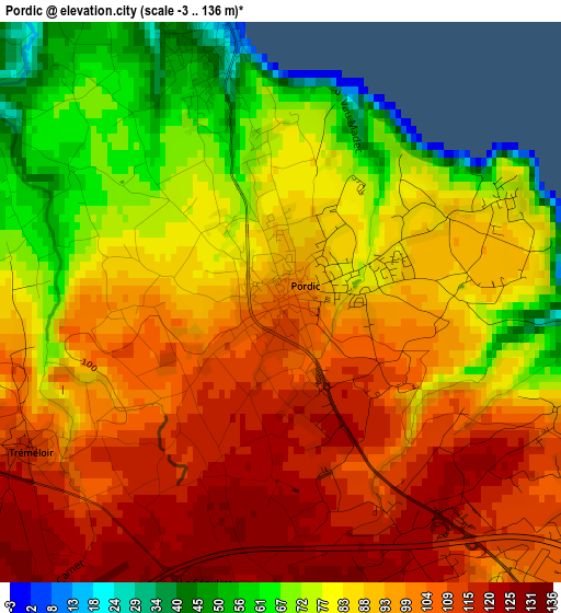
Below is the Elevation map of Pordic, which displays elevation range with different colors. Scale of the first map is from -3 to 136 m (-10 to 446 ft) with average elevation of 91.3 meters (=300 ft) [note 1]
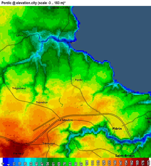
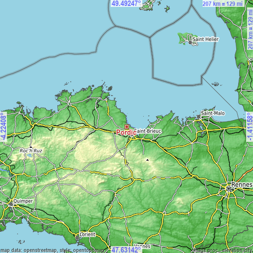
These maps also provides idea of topography and contour of this city, they are displayed at different zoom levels. More info about maps, scale and edge coordinates you can find below images.
| \ | Map #1 | Map #2 | Topo.Map |
| Scale [m] | -3..136 m | -3..183 m | × |
| Scale [ft] | -10..446 ft | -10..600 ft | × |
| Average | 91.3 m = 300 ft | 91.5 m = 300 ft | × |
| Width | 6.47 km = 4 mi | 12.93 km = 8 mi | 206.9 km = 128.6 mi |
| Height | 6.47 km = 4 mi | 12.93 km = 8 mi | 206.9 km = 128.6 mi |
| ↑Max Latitude | 48.59958° | 48.628634° | 49.49247° |
| Latitude at center | 48.57051° | 48.57051° | 48.57051° |
| ↓Min Latitude | 48.541423° | 48.51232° | 47.63142° |
| ← Min Longitude | -2.861775° | -2.905721° | -4.22408° |
| Longitude center | -2.81783° | -2.81783° | -2.81783° |
| →Max Longitude | -2.773885° | -2.729939° | -1.41158° |
Nearby cities:
Cities around Pordic sort by population:
• Saint-Brieuc elevation 96 m
7.2 km,  149°
149°
• Plérin 106 m
4.2 km,  138°
138°
• Ploufragan 128 m
9 km,  168°
168°
• Langueux 99 m
11.1 km, 138°
• Binic 5 m
3.4 km,  349°
349°
• Saint-Quay-Portrieux 24 m
8.9 km, 353°
• Plélo 116 m
9.6 km,  259°
259°
• Étables-sur-Mer 41 m
7.1 km, 350°
• Trémuson 140 m
5.7 km,  203°
203°
• La Méaugon 117 m
8.1 km,  190°
190°
• Lantic 65 m
6.2 km,  310°
310°
• Pléguien 74 m
11.5 km, 308°
Multilingual:
 En español:
Pordic elevación 103 m.
 En France:
Pordic élévation 103 m.


Sources and notes:
- [note 1] Map square and city borders are not equal. Map elevation data is calculated only from area inside that square.
- [src 1] Elevation data from geonames database provided with same terms of usage.
- [src 2] The elevation map of Pordic is generated using elevation data from NASA's 3 arcsec (90m) resolution SRTM data.
- [src 3] Base (background) map © OpenStreetMap contributors tiles are generated by Geofabrik and OpenTopoMap.
Copyright & License:
This Pordic Elevation Map is licensed under CC BY-SA. You may reuse any part from this page, if you give a proper credit by linking to this URL:
 More info on terms of use page.