Puymoyen elevation
Puymoyen (Nouvelle-Aquitaine, Charente), France elevation is 145 meters and Puymoyen elevation in feet is 476 ft above sea level [src 1]. Puymoyen is a populated place (feature code) with elevation that is 29 meters (95 ft) smaller than average city elevation in France.
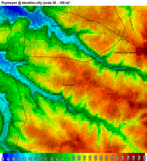
Below is the Elevation map of Puymoyen, which displays elevation range with different colors. Scale of the first map is from 36 to 169 m (118 to 554 ft) with average elevation of 111.7 meters (=366 ft) [note 1]
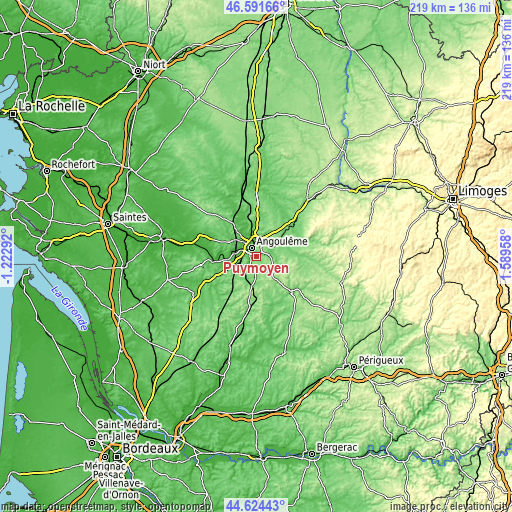
These maps also provides idea of topography and contour of this city, they are displayed at different zoom levels. More info about maps, scale and edge coordinates you can find below images.
| \ | Map #1 | Topo.Map |
| Scale [m] | 36..169 m | × |
| Scale [ft] | 118..554 ft | × |
| Average | 111.7 m = 366 ft | × |
| Width | 6.84 km = 4.3 mi | 218.7 km = 135.9 mi |
| Height | 6.84 km = 4.3 mi | 218.7 km = 135.9 mi |
| ↑Max Latitude | 45.647399° | 46.59166° |
| Latitude at center | 45.61667° | 45.61667° |
| ↓Min Latitude | 45.585924° | 44.62443° |
| ← Min Longitude | 0.139385° | -1.22292° |
| Longitude center | 0.18333° | 0.18333° |
| →Max Longitude | 0.227275° | 1.58958° |
Nearby cities:
Cities around Puymoyen sort by population:
• Angoulême elevation 103 m
4.5 km,  325°
325°
• Soyaux 126 m
3.9 km,  19°
19°
• Ruelle-sur-Touvre 70 m
8.4 km,  27°
27°
• La Couronne 47 m
6.5 km,  264°
264°
• Gond-Pontouvre 68 m
7.5 km,  350°
350°
• Saint-Michel 27 m
7.5 km,  299°
299°
• Fléac 32 m
8.5 km,  310°
310°
• Magnac-sur-Touvre 68 m
6.8 km, 34°
• Garat 72 m
6.7 km,  74°
74°
• Vœuil-et-Giget 75 m
4.5 km,  214°
214°
• Dirac 139 m
5.5 km,  109°
109°
• Touvre 51 m
7.6 km,  42°
42°
Multilingual:
 En español:
Puymoyen elevación 145 m.
 En France:
Puymoyen élévation 145 m.
 Auf Deutsch:
Puymoyen höhe über dem Meeresspiegel ist 145 m.

Sources and notes:
- [note 1] Map square and city borders are not equal. Map elevation data is calculated only from area inside that square.
- [src 1] Elevation data from geonames database provided with same terms of usage.
- [src 2] The elevation map of Puymoyen is generated using elevation data from NASA's 3 arcsec (90m) resolution SRTM data.
- [src 3] Base (background) map © OpenStreetMap contributors tiles are generated by Geofabrik and OpenTopoMap.
Copyright & License:
This Puymoyen Elevation Map is licensed under CC BY-SA. You may reuse any part from this page, if you give a proper credit by linking to this URL:
 More info on terms of use page.