Redon elevation
Redon (Brittany, Département d'Ille-et-Vilaine), France elevation is 25 meters and Redon elevation in feet is 82 ft above sea level [src 1]. Redon is a seat of a third-order administrative division (feature code) with elevation that is 149 meters (489 ft) smaller than average city elevation in France.
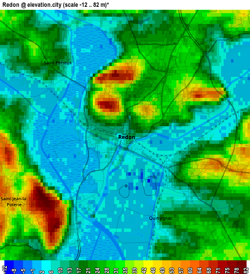
Below is the Elevation map of Redon, which displays elevation range with different colors. Scale of the first map is from -12 to 82 m (-39 to 269 ft) with average elevation of 18.6 meters (=61 ft) [note 1]
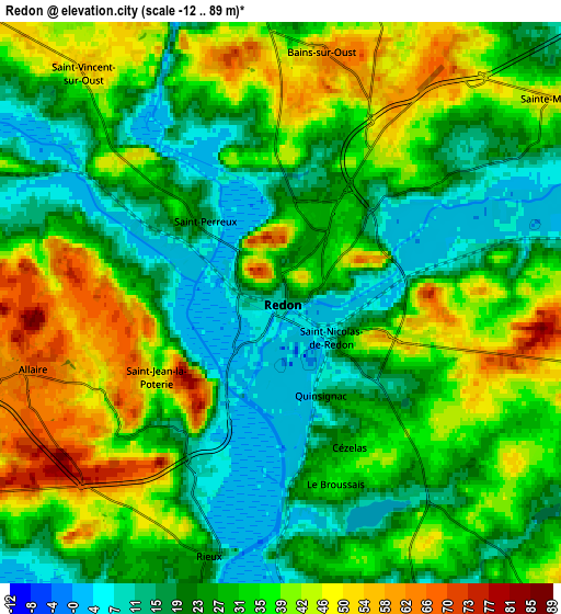
These maps also provides idea of topography and contour of this city, they are displayed at different zoom levels. More info about maps, scale and edge coordinates you can find below images.
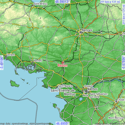
| \ | Map #1 | Map #2 | Topo.Map |
| Scale [m] | -12..82 m | -12..89 m | × |
| Scale [ft] | -39..269 ft | -39..292 ft | × |
| Average | 18.6 m = 61 ft | 30.5 m = 100 ft | × |
| Width | 6.58 km = 4.1 mi | 13.17 km = 8.2 mi | 210.7 km = 130.9 mi |
| Height | 6.58 km = 4.1 mi | 13.17 km = 8.2 mi | 210.6 km = 130.9 mi |
| ↑Max Latitude | 47.681005° | 47.710583° | 48.59013° |
| Latitude at center | 47.65141° | 47.65141° | 47.65141° |
| ↓Min Latitude | 47.621798° | 47.59217° | 46.6955° |
| ← Min Longitude | -2.128755° | -2.172701° | -3.49106° |
| Longitude center | -2.08481° | -2.08481° | -2.08481° |
| →Max Longitude | -2.040865° | -1.996919° | -0.67856° |
Nearby cities:
Cities around Redon sort by population:
• Allaire elevation 66 m
6.1 km,  255°
255°
• Bains-sur-Oust 63 m
5.9 km,  10°
10°
• Saint-Nicolas-de-Redon 32 m
1.9 km,  118°
118°
• Rieux 24 m
6.2 km,  196°
196°
• Avessac 54 m
7.1 km,  88°
88°
• Fégréac 33 m
8 km,  157°
157°
• Sainte-Marie 51 m
7.8 km,  52°
52°
• Saint-Jacut-les-Pins 58 m
10.5 km,  291°
291°
• Saint-Jean-la-Poterie 47 m
3.4 km,  239°
239°
• Sévérac 23 m
11.3 km,  176°
176°
• Saint-Vincent-sur-Oust 55 m
7.1 km,  319°
319°
• Saint-Perreux 17 m
2.7 km, 319°
Multilingual:
 En español:
Redon elevación 25 m.
 En France:
Redon élévation 25 m.


Sources and notes:
- [note 1] Map square and city borders are not equal. Map elevation data is calculated only from area inside that square.
- [src 1] Elevation data from geonames database provided with same terms of usage.
- [src 2] The elevation map of Redon is generated using elevation data from NASA's 3 arcsec (90m) resolution SRTM data.
- [src 3] Base (background) map © OpenStreetMap contributors tiles are generated by Geofabrik and OpenTopoMap.
Copyright & License:
This Redon Elevation Map is licensed under CC BY-SA. You may reuse any part from this page, if you give a proper credit by linking to this URL:
 More info on terms of use page.