Rives elevation
Rives (Auvergne-Rhône-Alpes, Département de l'Isère), France elevation is 353 meters and Rives elevation in feet is 1158 ft above sea level [src 1]. Rives is a populated place (feature code) with elevation that is 179 meters (587 ft) bigger than average city elevation in France.
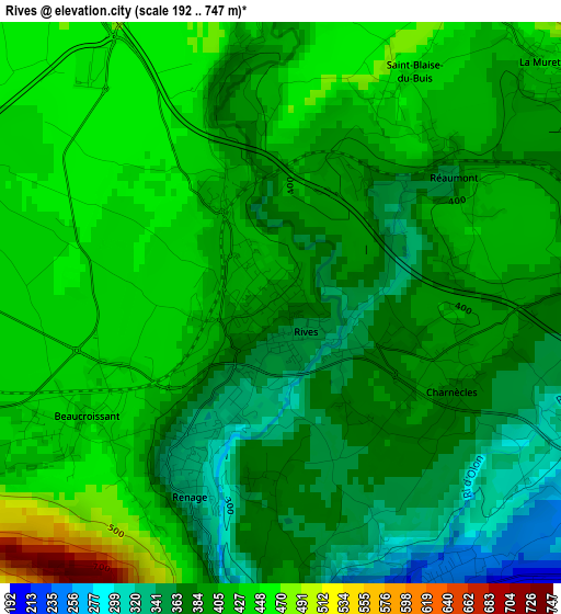
Below is the Elevation map of Rives, which displays elevation range with different colors. Scale of the first map is from 192 to 747 m (630 to 2451 ft) with average elevation of 404.2 meters (=1326 ft) [note 1]
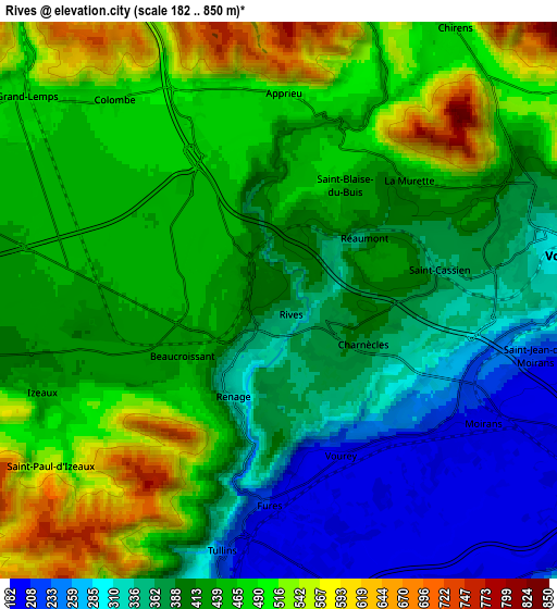
These maps also provides idea of topography and contour of this city, they are displayed at different zoom levels. More info about maps, scale and edge coordinates you can find below images.
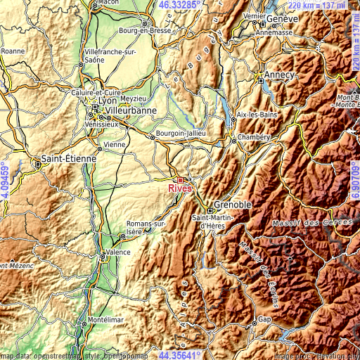
| \ | Map #1 | Map #2 | Topo.Map |
| Scale [m] | 192..747 m | 182..850 m | × |
| Scale [ft] | 630..2451 ft | 597..2789 ft | × |
| Average | 404.2 m = 1326 ft | 423.4 m = 1389 ft | × |
| Width | 6.87 km = 4.3 mi | 13.74 km = 8.5 mi | 219.8 km = 136.6 mi |
| Height | 6.87 km = 4.3 mi | 13.73 km = 8.5 mi | 219.7 km = 136.5 mi |
| ↑Max Latitude | 45.384133° | 45.41499° | 46.33285° |
| Latitude at center | 45.35326° | 45.35326° | 45.35326° |
| ↓Min Latitude | 45.32237° | 45.291463° | 44.35641° |
| ← Min Longitude | 5.456895° | 5.412949° | 4.09459° |
| Longitude center | 5.50084° | 5.50084° | 5.50084° |
| →Max Longitude | 5.544785° | 5.588731° | 6.90709° |
Nearby cities:
Cities around Rives sort by population:
• Voiron elevation 279 m
6.7 km,  79°
79°
• Moirans 200 m
4.8 km,  120°
120°
• Tullins 198 m
5.7 km,  187°
187°
• Renage 332 m
2.4 km,  203°
203°
• Apprieu 478 m
4.7 km,  359°
359°
• Izeaux 425 m
6.3 km,  250°
250°
• La Murette 438 m
4.3 km,  48°
48°
• Vourey 192 m
3.8 km,  157°
157°
• Colombe 519 m
6.4 km,  325°
325°
• Charnècles 360 m
2.4 km, 115°
• Beaucroissant 430 m
2.6 km,  243°
243°
• Saint-Cassien 345 m
3.7 km, 83°
Multilingual:
 En español:
Rives elevación 353 m.
 En France:
Rives élévation 353 m.


Sources and notes:
- [note 1] Map square and city borders are not equal. Map elevation data is calculated only from area inside that square.
- [src 1] Elevation data from geonames database provided with same terms of usage.
- [src 2] The elevation map of Rives is generated using elevation data from NASA's 3 arcsec (90m) resolution SRTM data.
- [src 3] Base (background) map © OpenStreetMap contributors tiles are generated by Geofabrik and OpenTopoMap.
Copyright & License:
This Rives Elevation Map is licensed under CC BY-SA. You may reuse any part from this page, if you give a proper credit by linking to this URL:
 More info on terms of use page.