Rohrbach-lès-Bitche elevation
Rohrbach-lès-Bitche (Grand Est, Moselle), France elevation is 327 meters and Rohrbach-lès-Bitche elevation in feet is 1073 ft above sea level [src 1]. Rohrbach-lès-Bitche is a populated place (feature code) with elevation that is 153 meters (502 ft) bigger than average city elevation in France.
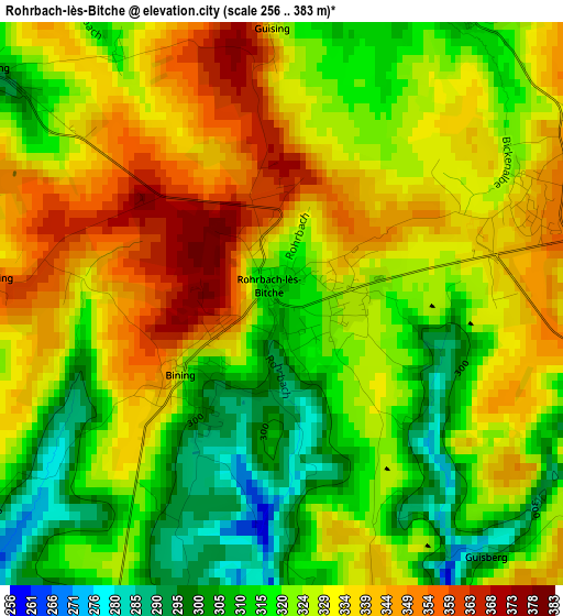
Below is the Elevation map of Rohrbach-lès-Bitche, which displays elevation range with different colors. Scale of the first map is from 256 to 383 m (840 to 1257 ft) with average elevation of 326.3 meters (=1071 ft) [note 1]
These maps also provides idea of topography and contour of this city, they are displayed at different zoom levels. More info about maps, scale and edge coordinates you can find below images.
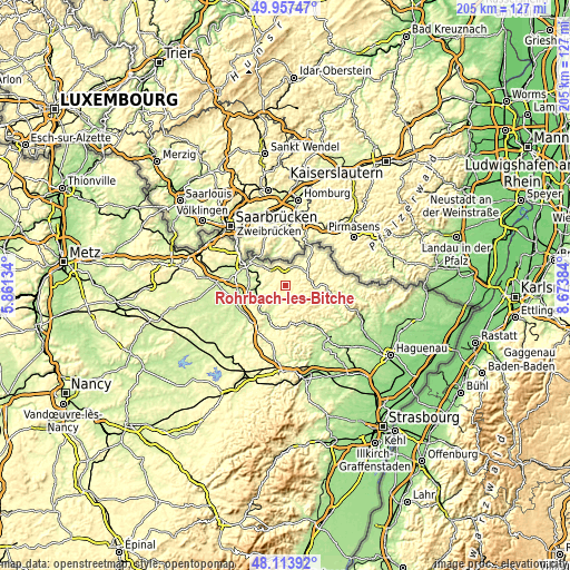
| \ | Map #1 | Topo.Map |
| Scale [m] | 256..383 m | × |
| Scale [ft] | 840..1257 ft | × |
| Average | 326.3 m = 1071 ft | × |
| Width | 6.41 km = 4 mi | 205 km = 127.4 mi |
| Height | 6.41 km = 4 mi | 205 km = 127.4 mi |
| ↑Max Latitude | 49.073037° | 49.95747° |
| Latitude at center | 49.04424° | 49.04424° |
| ↓Min Latitude | 49.015427° | 48.11392° |
| ← Min Longitude | 7.223645° | 5.86134° |
| Longitude center | 7.26759° | 7.26759° |
| →Max Longitude | 7.311535° | 8.67384° |
Nearby cities:
Cities around Rohrbach-lès-Bitche sort by population:
• Bitche elevation 310 m
11.9 km,  85°
85°
• Goetzenbruck 368 m
11 km,  132°
132°
• Montbronn 348 m
6.6 km,  151°
151°
• Lemberg 359 m
9.4 km,  120°
120°
• Petit-Réderching 348 m
3.1 km,  67°
67°
• Oermingen 256 m
11.2 km,  244°
244°
• Soucht 280 m
10.7 km, 152°
• Enchenberg 377 m
6.2 km, 123°
• Bining 314 m
1.3 km,  234°
234°
• Gros-Réderching 281 m
4.4 km,  307°
307°
• Wiesviller 299 m
8.6 km,  298°
298°
• Bliesbruck 259 m
10.1 km,  321°
321°
Multilingual:
 En español:
Rohrbach-lès-Bitche elevación 327 m.
 En France:
Rohrbach-lès-Bitche élévation 327 m.
 Auf Deutsch:
Rohrbach-lès-Bitche höhe über dem Meeresspiegel ist 327 m.
 На русском:
Rohrbach-lès-Bitche высота над уровнем моря 327 м
Sources and notes:
- [note 1] Map square and city borders are not equal. Map elevation data is calculated only from area inside that square.
- [src 1] Elevation data from geonames database provided with same terms of usage.
- [src 2] The elevation map of Rohrbach-lès-Bitche is generated using elevation data from NASA's 3 arcsec (90m) resolution SRTM data.
- [src 3] Base (background) map © OpenStreetMap contributors tiles are generated by Geofabrik and OpenTopoMap.
Copyright & License:
This Rohrbach-lès-Bitche Elevation Map is licensed under CC BY-SA. You may reuse any part from this page, if you give a proper credit by linking to this URL:
 More info on terms of use page.