Rueil-Malmaison elevation
Rueil-Malmaison (Île-de-France, Hauts-de-Seine), France elevation is 64 meters and Rueil-Malmaison elevation in feet is 210 ft above sea level [src 1]. Rueil-Malmaison is a populated place (feature code) with elevation that is 110 meters (361 ft) smaller than average city elevation in France.
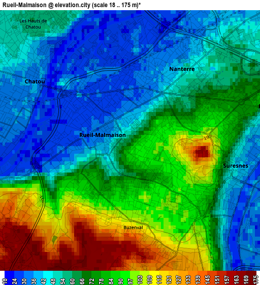
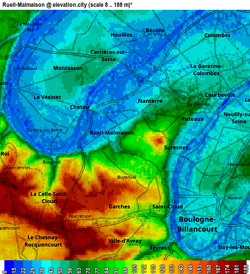
Below is the Elevation map of Rueil-Malmaison, which displays elevation range with different colors. Scale of the first map is from 18 to 175 m (59 to 574 ft) with average elevation of 68.9 meters (=226 ft) [note 1]
These maps also provides idea of topography and contour of this city, they are displayed at different zoom levels. More info about maps, scale and edge coordinates you can find below images.
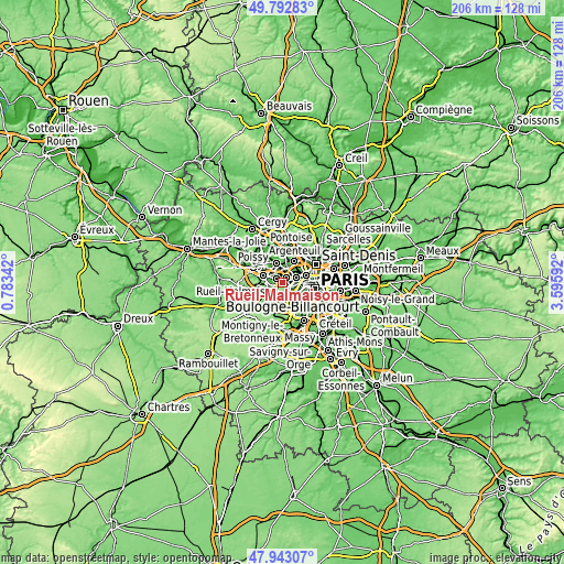
| \ | Map #1 | Map #2 | Topo.Map |
| Scale [m] | 18..175 m | 8..188 m | × |
| Scale [ft] | 59..574 ft | 26..617 ft | × |
| Average | 68.9 m = 226 ft | 68 m = 223 ft | × |
| Width | 6.43 km = 4 mi | 12.85 km = 8 mi | 205.7 km = 127.8 mi |
| Height | 6.43 km = 4 mi | 12.85 km = 8 mi | 205.7 km = 127.8 mi |
| ↑Max Latitude | 48.905394° | 48.934271° | 49.79283° |
| Latitude at center | 48.8765° | 48.8765° | 48.8765° |
| ↓Min Latitude | 48.84759° | 48.818662° | 47.94307° |
| ← Min Longitude | 2.145725° | 2.101779° | 0.78342° |
| Longitude center | 2.18967° | 2.18967° | 2.18967° |
| →Max Longitude | 2.233615° | 2.277561° | 3.59592° |
Nearby cities:
Cities around Rueil-Malmaison sort by population:
• Nanterre elevation 50 m
2.1 km,  35°
35°
• Suresnes 35 m
3 km,  101°
101°
• Puteaux 33 m
3.7 km,  77°
77°
• Chatou 36 m
2.7 km,  303°
303°
• Saint-Cloud 126 m
3.5 km,  164°
164°
• La Celle-Saint-Cloud 158 m
4.4 km,  228°
228°
• La Defense 53 m
4 km,  64°
64°
• Garches 134 m
3.8 km,  188°
188°
• Le Vésinet 41 m
4.5 km,  293°
293°
• Carrières-sur-Seine 41 m
3.5 km,  347°
347°
• Croissy-sur-Seine 32 m
3.8 km,  274°
274°
• Bougival 87 m
3.9 km,  245°
245°
Multilingual:
 En español:
Rueil-Malmaison elevación 64 m.
 En France:
Rueil-Malmaison élévation 64 m.
 Auf Deutsch:
Rueil-Malmaison höhe über dem Meeresspiegel ist 64 m.

Sources and notes:
- [note 1] Map square and city borders are not equal. Map elevation data is calculated only from area inside that square.
- [src 1] Elevation data from geonames database provided with same terms of usage.
- [src 2] The elevation map of Rueil-Malmaison is generated using elevation data from NASA's 3 arcsec (90m) resolution SRTM data.
- [src 3] Base (background) map © OpenStreetMap contributors tiles are generated by Geofabrik and OpenTopoMap.
Copyright & License:
This Rueil-Malmaison Elevation Map is licensed under CC BY-SA. You may reuse any part from this page, if you give a proper credit by linking to this URL:
 More info on terms of use page.