Sabres elevation
Sabres (Nouvelle-Aquitaine, Landes), France elevation is 80 meters and Sabres elevation in feet is 262 ft above sea level [src 1]. Sabres is a populated place (feature code) with elevation that is 94 meters (308 ft) smaller than average city elevation in France.
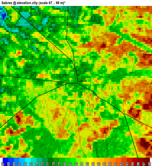
Below is the Elevation map of Sabres, which displays elevation range with different colors. Scale of the first map is from 67 to 98 m (220 to 322 ft) with average elevation of 83.5 meters (=274 ft) [note 1]
These maps also provides idea of topography and contour of this city, they are displayed at different zoom levels. More info about maps, scale and edge coordinates you can find below images.
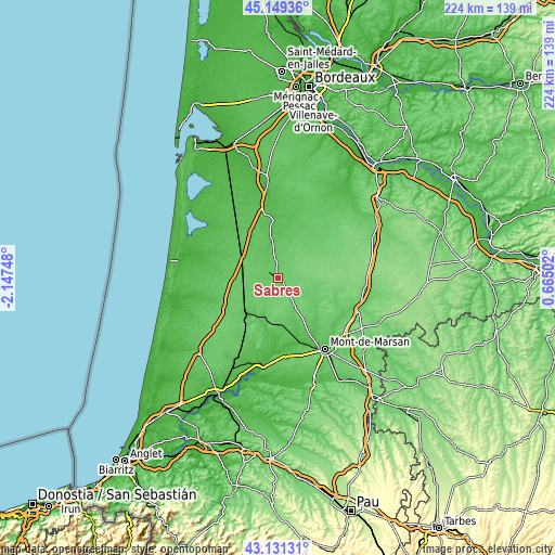
| \ | Map #1 | Topo.Map |
| Scale [m] | 67..98 m | × |
| Scale [ft] | 220..322 ft | × |
| Average | 83.5 m = 274 ft | × |
| Width | 7.01 km = 4.4 mi | 224.4 km = 139.4 mi |
| Height | 7.01 km = 4.4 mi | 224.4 km = 139.4 mi |
| ↑Max Latitude | 44.180484° | 45.14936° |
| Latitude at center | 44.14896° | 44.14896° |
| ↓Min Latitude | 44.117419° | 43.13131° |
| ← Min Longitude | -0.785175° | -2.14748° |
| Longitude center | -0.74123° | -0.74123° |
| →Max Longitude | -0.697285° | 0.66502° |
Nearby cities:
Cities around Sabres sort by population:
• Saint-Pierre-du-Mont elevation 79 m
34.2 km,  149°
149°
• Parentis-en-Born 32 m
34.7 km,  310°
310°
• Morcenx 76 m
18.7 km,  227°
227°
• Labouheyre 71 m
16 km,  296°
296°
• Rion-des-Landes 68 m
28 km,  211°
211°
• Ychoux 56 m
26.1 km,  319°
319°
• Ygos-Saint-Saturnin 73 m
19.2 km,  179°
179°
• Pissos 54 m
18 km,  350°
350°
• Pontenx-les-Forges 29 m
32 km,  288°
288°
• Saint-Perdon 81 m
33.7 km,  159°
159°
• Meilhan 67 m
31.8 km,  174°
174°
• Onesse-Laharie 43 m
28 km,  249°
249°
Multilingual:
 En español:
Sabres elevación 80 m.
 En France:
Sabres élévation 80 m.


Sources and notes:
- [note 1] Map square and city borders are not equal. Map elevation data is calculated only from area inside that square.
- [src 1] Elevation data from geonames database provided with same terms of usage.
- [src 2] The elevation map of Sabres is generated using elevation data from NASA's 3 arcsec (90m) resolution SRTM data.
- [src 3] Base (background) map © OpenStreetMap contributors tiles are generated by Geofabrik and OpenTopoMap.
Copyright & License:
This Sabres Elevation Map is licensed under CC BY-SA. You may reuse any part from this page, if you give a proper credit by linking to this URL:
 More info on terms of use page.